You are here: Home > Network List > NM - Cooperative New Madrid Seismic Network Stations List
> Station MPH Memphis, TN > Earthquake Result Viewer
MPH Memphis, TN - Earthquake Result Viewer
| Earthquake location: |
Northern Peru |
| Earthquake latitude/longitude: |
-4.5/-76.9 |
| Earthquake time(UTC): |
2022/02/03 (034) 15:58:56 GMT |
| Earthquake Depth: |
100 km |
| Earthquake Magnitude: |
6.5 mww |
| Earthquake Catalog/Contributor: |
NEIC PDE/us |
|
| Network: |
NM Cooperative New Madrid Seismic Network |
| Station: |
MPH Memphis, TN |
| Lat/Lon: |
35.12 N/89.93 W |
| Elevation: |
93 m |
|
| Distance: |
41.2 deg |
| Az: |
343.759 deg |
| Baz: |
160.113 deg |
| Ray Param: |
0.07357708 |
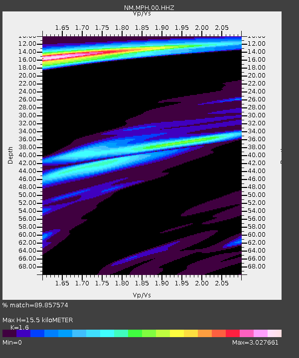
| Estimated Moho Depth: |
15.5 km |
| Estimated Crust Vp/Vs: |
1.60 |
| Assumed Crust Vp: |
6.38 km/s |
| Estimated Crust Vs: |
3.988 km/s |
| Estimated Crust Poisson's Ratio: |
0.18 |
|
| Radial Match: |
89.857574 % |
| Radial Bump: |
399 |
| Transverse Match: |
69.16428 % |
| Transverse Bump: |
331 |
| SOD ConfigId: |
26694651 |
| Insert Time: |
2022-02-17 16:25:20.390 +0000 |
| GWidth: |
2.5 |
| Max Bumps: |
400 |
| Tol: |
0.001 |
|

Signal To Noise
| Channel | StoN | STA | LTA |
| NM:MPH:00:HHZ:20220203T16:06:01.169995Z | 17.340818 | 8.521264E-6 | 4.913992E-7 |
| NM:MPH:00:HHN:20220203T16:06:01.169995Z | 7.017963 | 5.7504417E-6 | 8.19389E-7 |
| NM:MPH:00:HHE:20220203T16:06:01.169995Z | 3.297005 | 2.2672093E-6 | 6.8765723E-7 |
| Arrivals |
| Ps | 1.6 SECOND |
| PpPs | 5.9 SECOND |
| PsPs/PpSs | 7.4 SECOND |


