You are here: Home > Network List > O2 - Oklahoma Consolidated Temporary Seismic Networks Stations List
> Station DOVR Dover, Oklahoma, USA > Earthquake Result Viewer
DOVR Dover, Oklahoma, USA - Earthquake Result Viewer
| Earthquake location: |
Northern Peru |
| Earthquake latitude/longitude: |
-4.5/-76.9 |
| Earthquake time(UTC): |
2022/02/03 (034) 15:58:56 GMT |
| Earthquake Depth: |
100 km |
| Earthquake Magnitude: |
6.5 mww |
| Earthquake Catalog/Contributor: |
NEIC PDE/us |
|
| Network: |
O2 Oklahoma Consolidated Temporary Seismic Networks |
| Station: |
DOVR Dover, Oklahoma, USA |
| Lat/Lon: |
35.95 N/97.99 W |
| Elevation: |
337 m |
|
| Distance: |
44.8 deg |
| Az: |
335.561 deg |
| Baz: |
149.443 deg |
| Ray Param: |
0.07136876 |
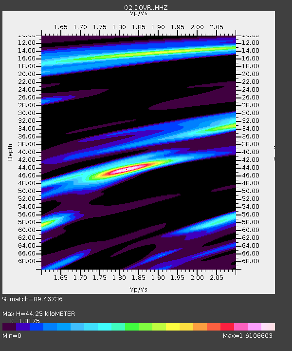
| Estimated Moho Depth: |
44.25 km |
| Estimated Crust Vp/Vs: |
1.82 |
| Assumed Crust Vp: |
6.426 km/s |
| Estimated Crust Vs: |
3.536 km/s |
| Estimated Crust Poisson's Ratio: |
0.28 |
|
| Radial Match: |
89.46736 % |
| Radial Bump: |
347 |
| Transverse Match: |
75.05846 % |
| Transverse Bump: |
400 |
| SOD ConfigId: |
26694651 |
| Insert Time: |
2022-02-17 16:27:17.482 +0000 |
| GWidth: |
2.5 |
| Max Bumps: |
400 |
| Tol: |
0.001 |
|

Signal To Noise
| Channel | StoN | STA | LTA |
| O2:DOVR: :HHZ:20220203T16:06:29.780011Z | 36.194885 | 6.5700697E-6 | 1.815193E-7 |
| O2:DOVR: :HHN:20220203T16:06:29.780011Z | 9.113284 | 2.1630594E-6 | 2.3735237E-7 |
| O2:DOVR: :HHE:20220203T16:06:29.780011Z | 12.28394 | 2.687411E-6 | 2.1877436E-7 |
| Arrivals |
| Ps | 6.0 SECOND |
| PpPs | 18 SECOND |
| PsPs/PpSs | 24 SECOND |


