You are here: Home > Network List > O2 - Oklahoma Consolidated Temporary Seismic Networks Stations List
> Station PW15 Ralston, Oklahoma, USA > Earthquake Result Viewer
PW15 Ralston, Oklahoma, USA - Earthquake Result Viewer
| Earthquake location: |
Northern Peru |
| Earthquake latitude/longitude: |
-4.5/-76.9 |
| Earthquake time(UTC): |
2022/02/03 (034) 15:58:56 GMT |
| Earthquake Depth: |
100 km |
| Earthquake Magnitude: |
6.5 mww |
| Earthquake Catalog/Contributor: |
NEIC PDE/us |
|
| Network: |
O2 Oklahoma Consolidated Temporary Seismic Networks |
| Station: |
PW15 Ralston, Oklahoma, USA |
| Lat/Lon: |
36.47 N/97.01 W |
| Elevation: |
270 m |
|
| Distance: |
44.8 deg |
| Az: |
336.893 deg |
| Baz: |
150.961 deg |
| Ray Param: |
0.07133325 |
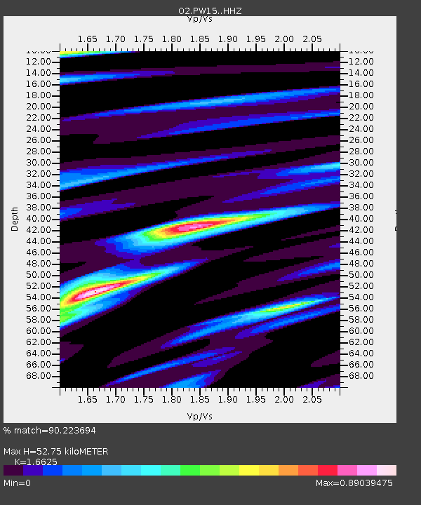
| Estimated Moho Depth: |
52.75 km |
| Estimated Crust Vp/Vs: |
1.66 |
| Assumed Crust Vp: |
6.483 km/s |
| Estimated Crust Vs: |
3.899 km/s |
| Estimated Crust Poisson's Ratio: |
0.22 |
|
| Radial Match: |
90.223694 % |
| Radial Bump: |
390 |
| Transverse Match: |
90.223656 % |
| Transverse Bump: |
390 |
| SOD ConfigId: |
26694651 |
| Insert Time: |
2022-02-17 16:27:57.472 +0000 |
| GWidth: |
2.5 |
| Max Bumps: |
400 |
| Tol: |
0.001 |
|

Signal To Noise
| Channel | StoN | STA | LTA |
| O2:PW15: :HHZ:20220203T16:06:30.199994Z | 38.55788 | 3.944137E-6 | 1.0229134E-7 |
| $trig.getChannelId() | $trig.getValue() | $trig.getSTA() | $trig.getLTA() |
| O2:PW15: :HHE:20220203T16:06:30.199994Z | 20.743652 | 4.4851927E-6 | 2.1622E-7 |
| Arrivals |
| Ps | 5.8 SECOND |
| PpPs | 20 SECOND |
| PsPs/PpSs | 26 SECOND |


