You are here: Home > Network List > O2 - Oklahoma Consolidated Temporary Seismic Networks Stations List
> Station SC07 Cyril, Oklahoma, USA > Earthquake Result Viewer
SC07 Cyril, Oklahoma, USA - Earthquake Result Viewer
| Earthquake location: |
Northern Peru |
| Earthquake latitude/longitude: |
-4.5/-76.9 |
| Earthquake time(UTC): |
2022/02/03 (034) 15:58:56 GMT |
| Earthquake Depth: |
100 km |
| Earthquake Magnitude: |
6.5 mww |
| Earthquake Catalog/Contributor: |
NEIC PDE/us |
|
| Network: |
O2 Oklahoma Consolidated Temporary Seismic Networks |
| Station: |
SC07 Cyril, Oklahoma, USA |
| Lat/Lon: |
34.93 N/98.21 W |
| Elevation: |
349 m |
|
| Distance: |
44.0 deg |
| Az: |
334.586 deg |
| Baz: |
148.615 deg |
| Ray Param: |
0.0718683 |
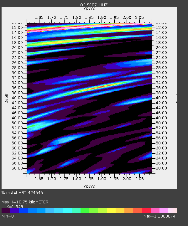
| Estimated Moho Depth: |
10.75 km |
| Estimated Crust Vp/Vs: |
1.95 |
| Assumed Crust Vp: |
6.315 km/s |
| Estimated Crust Vs: |
3.247 km/s |
| Estimated Crust Poisson's Ratio: |
0.32 |
|
| Radial Match: |
82.424545 % |
| Radial Bump: |
400 |
| Transverse Match: |
73.17308 % |
| Transverse Bump: |
400 |
| SOD ConfigId: |
26694651 |
| Insert Time: |
2022-02-17 16:28:16.192 +0000 |
| GWidth: |
2.5 |
| Max Bumps: |
400 |
| Tol: |
0.001 |
|

Signal To Noise
| Channel | StoN | STA | LTA |
| O2:SC07: :HHZ:20220203T16:06:23.590009Z | 36.494423 | 8.74084E-6 | 2.3951165E-7 |
| O2:SC07: :HHN:20220203T16:06:23.590009Z | 5.198708 | 1.4935554E-6 | 2.8729357E-7 |
| O2:SC07: :HHE:20220203T16:06:23.590009Z | 8.829287 | 2.1809592E-6 | 2.470142E-7 |
| Arrivals |
| Ps | 1.7 SECOND |
| PpPs | 4.7 SECOND |
| PsPs/PpSs | 6.4 SECOND |


