You are here: Home > Network List > O2 - Oklahoma Consolidated Temporary Seismic Networks Stations List
> Station SMNL Seminole, Oklahoma, USA > Earthquake Result Viewer
SMNL Seminole, Oklahoma, USA - Earthquake Result Viewer
| Earthquake location: |
Northern Peru |
| Earthquake latitude/longitude: |
-4.5/-76.9 |
| Earthquake time(UTC): |
2022/02/03 (034) 15:58:56 GMT |
| Earthquake Depth: |
100 km |
| Earthquake Magnitude: |
6.5 mww |
| Earthquake Catalog/Contributor: |
NEIC PDE/us |
|
| Network: |
O2 Oklahoma Consolidated Temporary Seismic Networks |
| Station: |
SMNL Seminole, Oklahoma, USA |
| Lat/Lon: |
35.29 N/96.56 W |
| Elevation: |
317 m |
|
| Distance: |
43.6 deg |
| Az: |
336.535 deg |
| Baz: |
150.966 deg |
| Ray Param: |
0.07209606 |
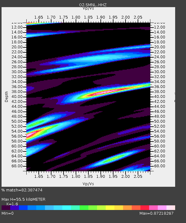
| Estimated Moho Depth: |
55.5 km |
| Estimated Crust Vp/Vs: |
1.60 |
| Assumed Crust Vp: |
6.426 km/s |
| Estimated Crust Vs: |
4.016 km/s |
| Estimated Crust Poisson's Ratio: |
0.18 |
|
| Radial Match: |
82.387474 % |
| Radial Bump: |
340 |
| Transverse Match: |
72.747284 % |
| Transverse Bump: |
400 |
| SOD ConfigId: |
26694651 |
| Insert Time: |
2022-02-17 16:28:34.094 +0000 |
| GWidth: |
2.5 |
| Max Bumps: |
400 |
| Tol: |
0.001 |
|

Signal To Noise
| Channel | StoN | STA | LTA |
| O2:SMNL: :HHZ:20220203T16:06:20.634992Z | 87.87065 | 7.773907E-6 | 8.846989E-8 |
| O2:SMNL: :HHN:20220203T16:06:20.634992Z | 13.636296 | 2.5346965E-6 | 1.8587866E-7 |
| O2:SMNL: :HHE:20220203T16:06:20.634992Z | 16.706656 | 2.2390204E-6 | 1.3401967E-7 |
| Arrivals |
| Ps | 5.6 SECOND |
| PpPs | 21 SECOND |
| PsPs/PpSs | 26 SECOND |


