You are here: Home > Network List > OH - Ohio Seismic Network Stations List
> Station CPOH Chapparal Prarie > Earthquake Result Viewer
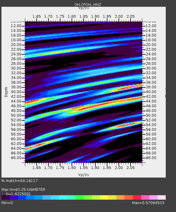
CPOH Chapparal Prarie - Earthquake Result Viewer
| Earthquake location: |
Northern Peru |
| Earthquake latitude/longitude: |
-4.5/-76.9 |
| Earthquake time(UTC): |
2022/02/03 (034) 15:58:56 GMT |
| Earthquake Depth: |
100 km |
| Earthquake Magnitude: |
6.5 mww |
| Earthquake Catalog/Contributor: |
NEIC PDE/us |
|
| Network: |
OH Ohio Seismic Network |
| Station: |
CPOH Chapparal Prarie |
| Lat/Lon: |
38.84 N/83.58 W |
| Elevation: |
289 m |
|
| Distance: |
43.5 deg |
| Az: |
352.466 deg |
| Baz: |
170.364 deg |
| Ray Param: |
0.072161235 |
| Estimated Moho Depth: |
63.25 km |
| Estimated Crust Vp/Vs: |
1.62 |
| Assumed Crust Vp: |
6.232 km/s |
| Estimated Crust Vs: |
3.841 km/s |
| Estimated Crust Poisson's Ratio: |
0.19 |
|
| Radial Match: |
84.16117 % |
| Radial Bump: |
394 |
| Transverse Match: |
66.4327 % |
| Transverse Bump: |
400 |
| SOD ConfigId: |
26694651 |
| Insert Time: |
2022-02-17 16:28:55.203 +0000 |
| GWidth: |
2.5 |
| Max Bumps: |
400 |
| Tol: |
0.001 |
|

Signal To Noise
| Channel | StoN | STA | LTA |
| OH:CPOH: :HHZ:20220203T16:06:19.715009Z | 57.296455 | 1.5006073E-7 | 2.619023E-9 |
| OH:CPOH: :HHN:20220203T16:06:19.715009Z | 10.002719 | 8.671558E-8 | 8.6692005E-9 |
| OH:CPOH: :HHE:20220203T16:06:19.715009Z | 1.8486389 | 1.2749584E-8 | 6.896741E-9 |
| Arrivals |
| Ps | 6.8 SECOND |
| PpPs | 25 SECOND |
| PsPs/PpSs | 32 SECOND |


