You are here: Home > Network List > PO - Portable Observatories for Lithospheric Analysis and Research Investigating Seis Stations List
> Station MATQ Matagami, QC > Earthquake Result Viewer
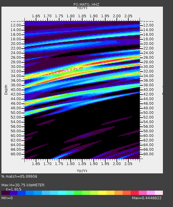
MATQ Matagami, QC - Earthquake Result Viewer
| Earthquake location: |
Northern Peru |
| Earthquake latitude/longitude: |
-4.5/-76.9 |
| Earthquake time(UTC): |
2022/02/03 (034) 15:58:56 GMT |
| Earthquake Depth: |
100 km |
| Earthquake Magnitude: |
6.5 mww |
| Earthquake Catalog/Contributor: |
NEIC PDE/us |
|
| Network: |
PO Portable Observatories for Lithospheric Analysis and Research Investigating Seis |
| Station: |
MATQ Matagami, QC |
| Lat/Lon: |
49.76 N/77.64 W |
| Elevation: |
280 m |
|
| Distance: |
54.0 deg |
| Az: |
359.44 deg |
| Baz: |
179.14 deg |
| Ray Param: |
0.06543621 |
| Estimated Moho Depth: |
30.75 km |
| Estimated Crust Vp/Vs: |
1.82 |
| Assumed Crust Vp: |
6.61 km/s |
| Estimated Crust Vs: |
3.642 km/s |
| Estimated Crust Poisson's Ratio: |
0.28 |
|
| Radial Match: |
85.89906 % |
| Radial Bump: |
400 |
| Transverse Match: |
76.70867 % |
| Transverse Bump: |
400 |
| SOD ConfigId: |
26694651 |
| Insert Time: |
2022-02-17 16:30:35.425 +0000 |
| GWidth: |
2.5 |
| Max Bumps: |
400 |
| Tol: |
0.001 |
|

Signal To Noise
| Channel | StoN | STA | LTA |
| PO:MATQ: :HHZ:20220203T16:07:39.739972Z | 30.545683 | 4.089239E-6 | 1.338729E-7 |
| PO:MATQ: :HHN:20220203T16:07:39.739972Z | 10.005787 | 1.8175913E-6 | 1.81654E-7 |
| PO:MATQ: :HHE:20220203T16:07:39.739972Z | 7.679307 | 7.603792E-7 | 9.901664E-8 |
| Arrivals |
| Ps | 4.0 SECOND |
| PpPs | 12 SECOND |
| PsPs/PpSs | 16 SECOND |


