You are here: Home > Network List > TX - Texas Seismological Network Stations List
> Station PB21 Reeves Ward Border > Earthquake Result Viewer
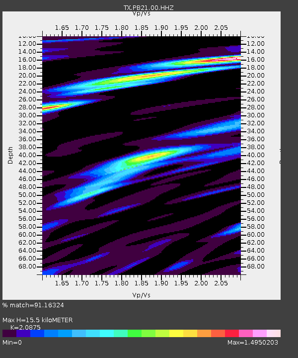
PB21 Reeves Ward Border - Earthquake Result Viewer
| Earthquake location: |
Northern Peru |
| Earthquake latitude/longitude: |
-4.5/-76.9 |
| Earthquake time(UTC): |
2022/02/03 (034) 15:58:56 GMT |
| Earthquake Depth: |
100 km |
| Earthquake Magnitude: |
6.5 mww |
| Earthquake Catalog/Contributor: |
NEIC PDE/us |
|
| Network: |
TX Texas Seismological Network |
| Station: |
PB21 Reeves Ward Border |
| Lat/Lon: |
31.34 N/103.06 W |
| Elevation: |
753 m |
|
| Distance: |
43.4 deg |
| Az: |
326.783 deg |
| Baz: |
140.332 deg |
| Ray Param: |
0.0721909 |
| Estimated Moho Depth: |
15.5 km |
| Estimated Crust Vp/Vs: |
2.09 |
| Assumed Crust Vp: |
6.121 km/s |
| Estimated Crust Vs: |
2.932 km/s |
| Estimated Crust Poisson's Ratio: |
0.35 |
|
| Radial Match: |
91.16324 % |
| Radial Bump: |
400 |
| Transverse Match: |
78.50118 % |
| Transverse Bump: |
400 |
| SOD ConfigId: |
26694651 |
| Insert Time: |
2022-02-17 16:33:50.955 +0000 |
| GWidth: |
2.5 |
| Max Bumps: |
400 |
| Tol: |
0.001 |
|

Signal To Noise
| Channel | StoN | STA | LTA |
| TX:PB21:00:HHZ:20220203T16:06:19.190015Z | 39.292446 | 4.4784515E-6 | 1.13977414E-7 |
| TX:PB21:00:HH1:20220203T16:06:19.190015Z | 12.249526 | 1.6421592E-6 | 1.34059E-7 |
| TX:PB21:00:HH2:20220203T16:06:19.190015Z | 14.15434 | 1.5787396E-6 | 1.11537496E-7 |
| Arrivals |
| Ps | 2.9 SECOND |
| PpPs | 7.4 SECOND |
| PsPs/PpSs | 10 SECOND |


