You are here: Home > Network List > TX - Texas Seismological Network Stations List
> Station PB30 Pecos City Water South > Earthquake Result Viewer
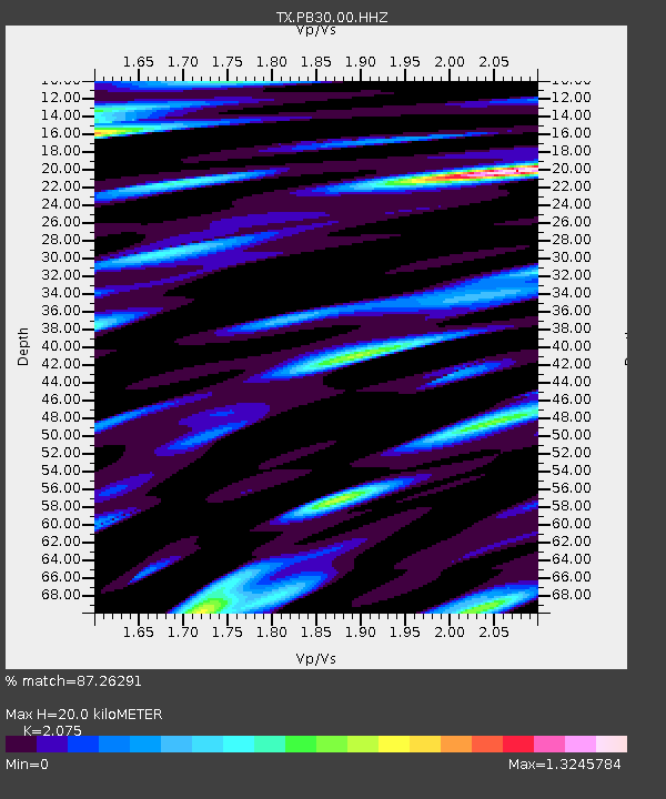
PB30 Pecos City Water South - Earthquake Result Viewer
| Earthquake location: |
Northern Peru |
| Earthquake latitude/longitude: |
-4.5/-76.9 |
| Earthquake time(UTC): |
2022/02/03 (034) 15:58:56 GMT |
| Earthquake Depth: |
100 km |
| Earthquake Magnitude: |
6.5 mww |
| Earthquake Catalog/Contributor: |
NEIC PDE/us |
|
| Network: |
TX Texas Seismological Network |
| Station: |
PB30 Pecos City Water South |
| Lat/Lon: |
31.28 N/103.32 W |
| Elevation: |
829 m |
|
| Distance: |
43.5 deg |
| Az: |
326.477 deg |
| Baz: |
139.976 deg |
| Ray Param: |
0.07214484 |
| Estimated Moho Depth: |
20.0 km |
| Estimated Crust Vp/Vs: |
2.08 |
| Assumed Crust Vp: |
6.121 km/s |
| Estimated Crust Vs: |
2.95 km/s |
| Estimated Crust Poisson's Ratio: |
0.35 |
|
| Radial Match: |
87.26291 % |
| Radial Bump: |
400 |
| Transverse Match: |
80.2812 % |
| Transverse Bump: |
400 |
| SOD ConfigId: |
26694651 |
| Insert Time: |
2022-02-17 16:33:57.169 +0000 |
| GWidth: |
2.5 |
| Max Bumps: |
400 |
| Tol: |
0.001 |
|

Signal To Noise
| Channel | StoN | STA | LTA |
| TX:PB30:00:HHZ:20220203T16:06:19.960004Z | 15.97242 | 4.4511257E-6 | 2.7867574E-7 |
| TX:PB30:00:HH1:20220203T16:06:19.960004Z | 9.985952 | 1.8502865E-6 | 1.8528894E-7 |
| TX:PB30:00:HH2:20220203T16:06:19.960004Z | 14.899901 | 2.525015E-6 | 1.6946521E-7 |
| Arrivals |
| Ps | 3.7 SECOND |
| PpPs | 9.6 SECOND |
| PsPs/PpSs | 13 SECOND |


