You are here: Home > Network List > TX - Texas Seismological Network Stations List
> Station PB33 CR 111 > Earthquake Result Viewer
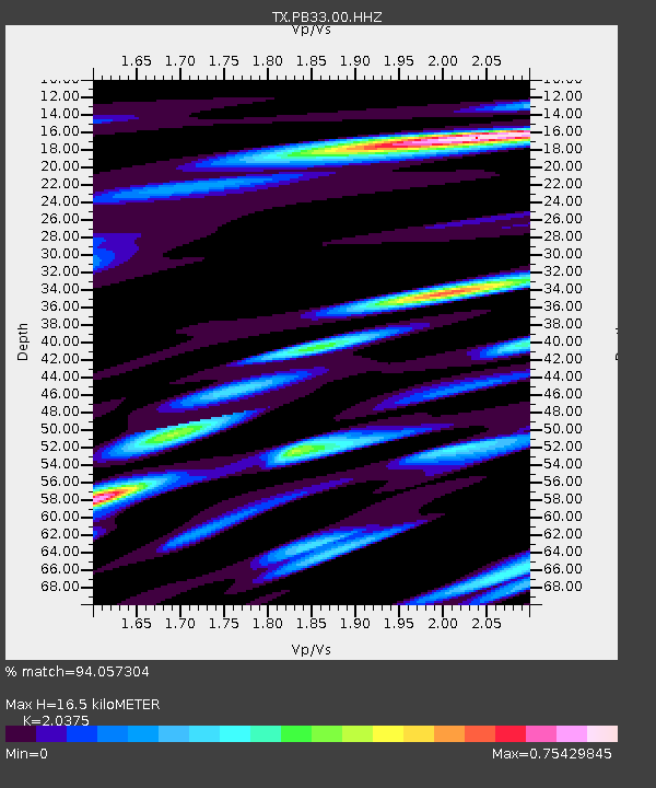
PB33 CR 111 - Earthquake Result Viewer
| Earthquake location: |
Northern Peru |
| Earthquake latitude/longitude: |
-4.5/-76.9 |
| Earthquake time(UTC): |
2022/02/03 (034) 15:58:56 GMT |
| Earthquake Depth: |
100 km |
| Earthquake Magnitude: |
6.5 mww |
| Earthquake Catalog/Contributor: |
NEIC PDE/us |
|
| Network: |
TX Texas Seismological Network |
| Station: |
PB33 CR 111 |
| Lat/Lon: |
31.53 N/104.05 W |
| Elevation: |
1006 m |
|
| Distance: |
44.1 deg |
| Az: |
326.027 deg |
| Baz: |
139.271 deg |
| Ray Param: |
0.07177626 |
| Estimated Moho Depth: |
16.5 km |
| Estimated Crust Vp/Vs: |
2.04 |
| Assumed Crust Vp: |
6.361 km/s |
| Estimated Crust Vs: |
3.122 km/s |
| Estimated Crust Poisson's Ratio: |
0.34 |
|
| Radial Match: |
94.057304 % |
| Radial Bump: |
329 |
| Transverse Match: |
62.876083 % |
| Transverse Bump: |
400 |
| SOD ConfigId: |
26694651 |
| Insert Time: |
2022-02-17 16:33:57.787 +0000 |
| GWidth: |
2.5 |
| Max Bumps: |
400 |
| Tol: |
0.001 |
|

Signal To Noise
| Channel | StoN | STA | LTA |
| TX:PB33:00:HHZ:20220203T16:06:24.729993Z | 35.258858 | 4.85158E-7 | 1.375989E-8 |
| TX:PB33:00:HH1:20220203T16:06:24.729993Z | 7.527005 | 2.3011619E-7 | 3.0572078E-8 |
| TX:PB33:00:HH2:20220203T16:06:24.729993Z | 3.4716432 | 1.1899927E-7 | 3.4277505E-8 |
| Arrivals |
| Ps | 2.8 SECOND |
| PpPs | 7.5 SECOND |
| PsPs/PpSs | 10 SECOND |


