You are here: Home > Network List > TX - Texas Seismological Network Stations List
> Station SNAG San Augustine > Earthquake Result Viewer
SNAG San Augustine - Earthquake Result Viewer
| Earthquake location: |
Northern Peru |
| Earthquake latitude/longitude: |
-4.5/-76.9 |
| Earthquake time(UTC): |
2022/02/03 (034) 15:58:56 GMT |
| Earthquake Depth: |
100 km |
| Earthquake Magnitude: |
6.5 mww |
| Earthquake Catalog/Contributor: |
NEIC PDE/us |
|
| Network: |
TX Texas Seismological Network |
| Station: |
SNAG San Augustine |
| Lat/Lon: |
31.52 N/94.18 W |
| Elevation: |
84 m |
|
| Distance: |
39.4 deg |
| Az: |
336.482 deg |
| Baz: |
152.235 deg |
| Ray Param: |
0.074687526 |
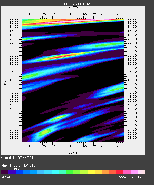
| Estimated Moho Depth: |
11.0 km |
| Estimated Crust Vp/Vs: |
1.87 |
| Assumed Crust Vp: |
5.738 km/s |
| Estimated Crust Vs: |
3.077 km/s |
| Estimated Crust Poisson's Ratio: |
0.30 |
|
| Radial Match: |
87.44724 % |
| Radial Bump: |
355 |
| Transverse Match: |
69.60593 % |
| Transverse Bump: |
400 |
| SOD ConfigId: |
26694651 |
| Insert Time: |
2022-02-17 16:34:23.145 +0000 |
| GWidth: |
2.5 |
| Max Bumps: |
400 |
| Tol: |
0.001 |
|
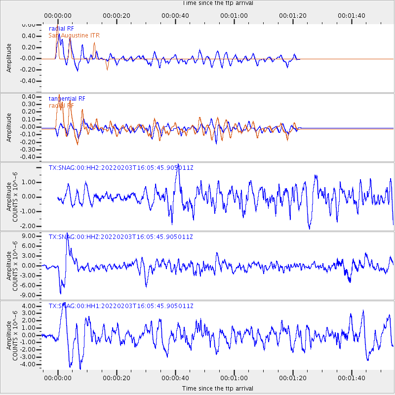
Signal To Noise
| Channel | StoN | STA | LTA |
| TX:SNAG:00:HHZ:20220203T16:05:45.905011Z | 17.180481 | 5.065409E-6 | 2.948351E-7 |
| TX:SNAG:00:HH1:20220203T16:05:45.905011Z | 6.292886 | 2.8515758E-6 | 4.531428E-7 |
| TX:SNAG:00:HH2:20220203T16:05:45.905011Z | 1.4483397 | 4.9025226E-7 | 3.3849258E-7 |
| Arrivals |
| Ps | 1.7 SECOND |
| PpPs | 5.2 SECOND |
| PsPs/PpSs | 7.0 SECOND |


