You are here: Home > Network List > UU - University of Utah Regional Network Stations List
> Station MCU Monte Cristo, UT, USA > Earthquake Result Viewer
MCU Monte Cristo, UT, USA - Earthquake Result Viewer
| Earthquake location: |
Northern Peru |
| Earthquake latitude/longitude: |
-4.5/-76.9 |
| Earthquake time(UTC): |
2022/02/03 (034) 15:58:56 GMT |
| Earthquake Depth: |
100 km |
| Earthquake Magnitude: |
6.5 mww |
| Earthquake Catalog/Contributor: |
NEIC PDE/us |
|
| Network: |
UU University of Utah Regional Network |
| Station: |
MCU Monte Cristo, UT, USA |
| Lat/Lon: |
41.46 N/111.51 W |
| Elevation: |
2668 m |
|
| Distance: |
55.5 deg |
| Az: |
328.845 deg |
| Baz: |
136.663 deg |
| Ray Param: |
0.06445146 |
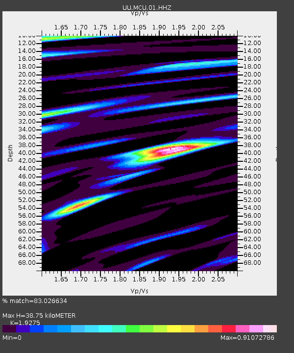
| Estimated Moho Depth: |
38.75 km |
| Estimated Crust Vp/Vs: |
1.93 |
| Assumed Crust Vp: |
6.155 km/s |
| Estimated Crust Vs: |
3.193 km/s |
| Estimated Crust Poisson's Ratio: |
0.32 |
|
| Radial Match: |
83.026634 % |
| Radial Bump: |
400 |
| Transverse Match: |
80.14497 % |
| Transverse Bump: |
400 |
| SOD ConfigId: |
26694651 |
| Insert Time: |
2022-02-17 16:37:14.894 +0000 |
| GWidth: |
2.5 |
| Max Bumps: |
400 |
| Tol: |
0.001 |
|

Signal To Noise
| Channel | StoN | STA | LTA |
| UU:MCU:01:HHZ:20220203T16:07:50.679975Z | 47.158657 | 4.109788E-6 | 8.71481E-8 |
| UU:MCU:01:HHN:20220203T16:07:50.679975Z | 16.987585 | 1.2804378E-6 | 7.537492E-8 |
| UU:MCU:01:HHE:20220203T16:07:50.679975Z | 14.067269 | 1.5618019E-6 | 1.11023816E-7 |
| Arrivals |
| Ps | 6.1 SECOND |
| PpPs | 18 SECOND |
| PsPs/PpSs | 24 SECOND |


