You are here: Home > Network List > UW - Pacific Northwest Regional Seismic Network Stations List
> Station WYNO Wynoochee Dam Area, Olympic National Forest, WA, USA > Earthquake Result Viewer
WYNO Wynoochee Dam Area, Olympic National Forest, WA, USA - Earthquake Result Viewer
| Earthquake location: |
Northern Peru |
| Earthquake latitude/longitude: |
-4.5/-76.9 |
| Earthquake time(UTC): |
2022/02/03 (034) 15:58:56 GMT |
| Earthquake Depth: |
100 km |
| Earthquake Magnitude: |
6.5 mww |
| Earthquake Catalog/Contributor: |
NEIC PDE/us |
|
| Network: |
UW Pacific Northwest Regional Seismic Network |
| Station: |
WYNO Wynoochee Dam Area, Olympic National Forest, WA, USA |
| Lat/Lon: |
47.43 N/123.61 W |
| Elevation: |
935 m |
|
| Distance: |
65.9 deg |
| Az: |
327.256 deg |
| Baz: |
127.408 deg |
| Ray Param: |
0.057685826 |
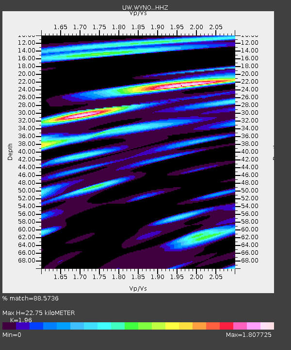
| Estimated Moho Depth: |
22.75 km |
| Estimated Crust Vp/Vs: |
1.96 |
| Assumed Crust Vp: |
6.566 km/s |
| Estimated Crust Vs: |
3.35 km/s |
| Estimated Crust Poisson's Ratio: |
0.32 |
|
| Radial Match: |
88.5736 % |
| Radial Bump: |
400 |
| Transverse Match: |
88.32789 % |
| Transverse Bump: |
400 |
| SOD ConfigId: |
26694651 |
| Insert Time: |
2022-02-17 16:39:35.417 +0000 |
| GWidth: |
2.5 |
| Max Bumps: |
400 |
| Tol: |
0.001 |
|

Signal To Noise
| Channel | StoN | STA | LTA |
| UW:WYNO: :HHZ:20220203T16:09:01.170026Z | 23.043411 | 3.8736425E-6 | 1.6810196E-7 |
| UW:WYNO: :HHN:20220203T16:09:01.170026Z | 9.675194 | 1.968682E-6 | 2.0347728E-7 |
| UW:WYNO: :HHE:20220203T16:09:01.170026Z | 6.493838 | 1.4723108E-6 | 2.2672431E-7 |
| Arrivals |
| Ps | 3.5 SECOND |
| PpPs | 9.9 SECOND |
| PsPs/PpSs | 13 SECOND |


