You are here: Home > Network List > XL17 - McGill Dawson-Septimus Induced Seismicity Study () Stations List
> Station MG04 Z > Earthquake Result Viewer
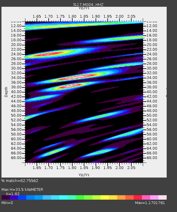
MG04 Z - Earthquake Result Viewer
| Earthquake location: |
Northern Peru |
| Earthquake latitude/longitude: |
-4.5/-76.9 |
| Earthquake time(UTC): |
2022/02/03 (034) 15:58:56 GMT |
| Earthquake Depth: |
100 km |
| Earthquake Magnitude: |
6.5 mww |
| Earthquake Catalog/Contributor: |
NEIC PDE/us |
|
| Network: |
XL McGill Dawson-Septimus Induced Seismicity Study () |
| Station: |
MG04 Z |
| Lat/Lon: |
55.99 N/120.34 W |
| Elevation: |
682 m |
|
| Distance: |
69.9 deg |
| Az: |
335.73 deg |
| Baz: |
133.17 deg |
| Ray Param: |
0.05508729 |
| Estimated Moho Depth: |
33.5 km |
| Estimated Crust Vp/Vs: |
1.82 |
| Assumed Crust Vp: |
6.303 km/s |
| Estimated Crust Vs: |
3.463 km/s |
| Estimated Crust Poisson's Ratio: |
0.28 |
|
| Radial Match: |
82.75562 % |
| Radial Bump: |
400 |
| Transverse Match: |
79.223335 % |
| Transverse Bump: |
400 |
| SOD ConfigId: |
26694651 |
| Insert Time: |
2022-02-17 16:41:10.004 +0000 |
| GWidth: |
2.5 |
| Max Bumps: |
400 |
| Tol: |
0.001 |
|

Signal To Noise
| Channel | StoN | STA | LTA |
| XL:MG04: :HHZ:20220203T16:09:26.110028Z | 19.91924 | 3.8833036E-6 | 1.9495238E-7 |
| XL:MG04: :HHN:20220203T16:09:26.110028Z | 1.8472099 | 5.299134E-7 | 2.868723E-7 |
| XL:MG04: :HHE:20220203T16:09:26.110028Z | 6.1700397 | 1.6707123E-6 | 2.7077823E-7 |
| Arrivals |
| Ps | 4.5 SECOND |
| PpPs | 14 SECOND |
| PsPs/PpSs | 19 SECOND |


