You are here: Home > Network List > TX - Texas Seismological Network Stations List
> Station SAND Sanderson > Earthquake Result Viewer
SAND Sanderson - Earthquake Result Viewer
| Earthquake location: |
Chile-Argentina Border Region |
| Earthquake latitude/longitude: |
-24.3/-67.1 |
| Earthquake time(UTC): |
2018/06/21 (172) 16:08:02 GMT |
| Earthquake Depth: |
175 km |
| Earthquake Magnitude: |
5.7 Mww |
| Earthquake Catalog/Contributor: |
NEIC PDE/us |
|
| Network: |
TX Texas Seismological Network |
| Station: |
SAND Sanderson |
| Lat/Lon: |
29.95 N/102.12 W |
| Elevation: |
689 m |
|
| Distance: |
63.6 deg |
| Az: |
326.181 deg |
| Baz: |
144.192 deg |
| Ray Param: |
0.05894982 |
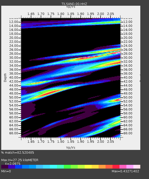
| Estimated Moho Depth: |
27.25 km |
| Estimated Crust Vp/Vs: |
2.10 |
| Assumed Crust Vp: |
6.419 km/s |
| Estimated Crust Vs: |
3.06 km/s |
| Estimated Crust Poisson's Ratio: |
0.35 |
|
| Radial Match: |
82.520485 % |
| Radial Bump: |
283 |
| Transverse Match: |
77.958824 % |
| Transverse Bump: |
327 |
| SOD ConfigId: |
2709371 |
| Insert Time: |
2018-07-05 16:16:36.286 +0000 |
| GWidth: |
2.5 |
| Max Bumps: |
400 |
| Tol: |
0.001 |
|

Signal To Noise
| Channel | StoN | STA | LTA |
| TX:SAND:00:HHZ:20180621T16:17:43.365002Z | 15.542568 | 1.5734698E-6 | 1.01236154E-7 |
| TX:SAND:00:HH1:20180621T16:17:43.365002Z | 7.4749837 | 4.8939035E-7 | 6.5470424E-8 |
| TX:SAND:00:HH2:20180621T16:17:43.365002Z | 8.131867 | 6.325502E-7 | 7.778659E-8 |
| Arrivals |
| Ps | 4.8 SECOND |
| PpPs | 13 SECOND |
| PsPs/PpSs | 18 SECOND |


