You are here: Home > Network List > US - United States National Seismic Network Stations List
> Station HDIL Hopedale, Illinois, USA > Earthquake Result Viewer
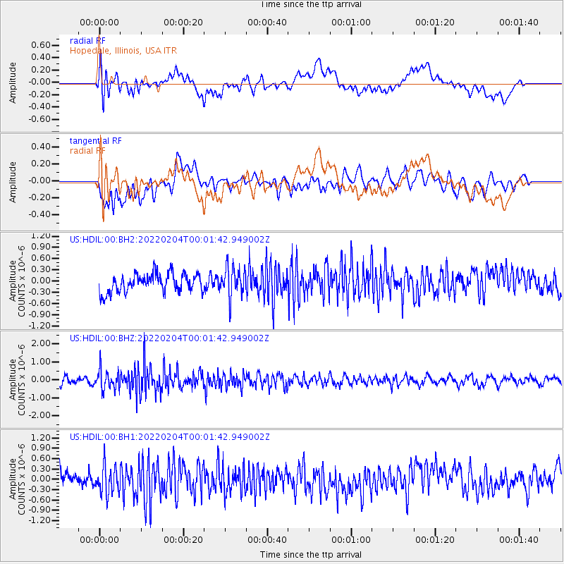
HDIL Hopedale, Illinois, USA - Earthquake Result Viewer
*The percent match for this event was below the threshold and hence no stack was calculated.
| Earthquake location: |
Alaska Peninsula |
| Earthquake latitude/longitude: |
54.3/-161.6 |
| Earthquake time(UTC): |
2022/02/03 (034) 23:53:32 GMT |
| Earthquake Depth: |
35 km |
| Earthquake Magnitude: |
5.4 Mww |
| Earthquake Catalog/Contributor: |
NEIC PDE/us |
|
| Network: |
US United States National Seismic Network |
| Station: |
HDIL Hopedale, Illinois, USA |
| Lat/Lon: |
40.56 N/89.29 W |
| Elevation: |
219 m |
|
| Distance: |
48.7 deg |
| Az: |
75.151 deg |
| Baz: |
311.926 deg |
| Ray Param: |
$rayparam |
*The percent match for this event was below the threshold and hence was not used in the summary stack. |
|
| Radial Match: |
54.951088 % |
| Radial Bump: |
400 |
| Transverse Match: |
52.365852 % |
| Transverse Bump: |
400 |
| SOD ConfigId: |
26694651 |
| Insert Time: |
2022-02-18 00:12:30.103 +0000 |
| GWidth: |
2.5 |
| Max Bumps: |
400 |
| Tol: |
0.001 |
|
Signal To Noise
| Channel | StoN | STA | LTA |
| US:HDIL:00:BHZ:20220204T00:01:42.949002Z | 3.4041297 | 5.6475716E-7 | 1.6590353E-7 |
| US:HDIL:00:BH1:20220204T00:01:42.949002Z | 1.8937861 | 4.179928E-7 | 2.2071806E-7 |
| US:HDIL:00:BH2:20220204T00:01:42.949002Z | 1.6488085 | 4.0593676E-7 | 2.4620007E-7 |
| Arrivals |
| Ps | |
| PpPs | |
| PsPs/PpSs | |


