You are here: Home > Network List > US - United States National Seismic Network Stations List
> Station AMTX Amarillo, Texas, USA > Earthquake Result Viewer
AMTX Amarillo, Texas, USA - Earthquake Result Viewer
*The percent match for this event was below the threshold and hence no stack was calculated.
| Earthquake location: |
Chile-Argentina Border Region |
| Earthquake latitude/longitude: |
-24.3/-67.1 |
| Earthquake time(UTC): |
2018/06/21 (172) 16:08:02 GMT |
| Earthquake Depth: |
175 km |
| Earthquake Magnitude: |
5.7 Mww |
| Earthquake Catalog/Contributor: |
NEIC PDE/us |
|
| Network: |
US United States National Seismic Network |
| Station: |
AMTX Amarillo, Texas, USA |
| Lat/Lon: |
34.53 N/101.41 W |
| Elevation: |
1010 m |
|
| Distance: |
67.0 deg |
| Az: |
329.601 deg |
| Baz: |
146.002 deg |
| Ray Param: |
$rayparam |
*The percent match for this event was below the threshold and hence was not used in the summary stack. |
|
| Radial Match: |
59.26895 % |
| Radial Bump: |
400 |
| Transverse Match: |
60.179363 % |
| Transverse Bump: |
400 |
| SOD ConfigId: |
2709371 |
| Insert Time: |
2018-07-05 16:17:34.333 +0000 |
| GWidth: |
2.5 |
| Max Bumps: |
400 |
| Tol: |
0.001 |
|
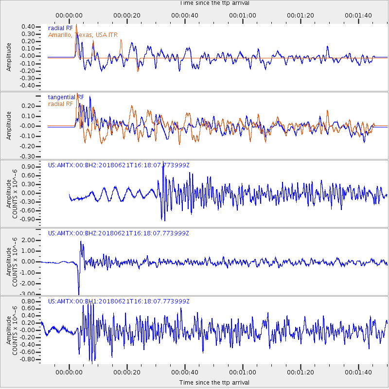
Signal To Noise
| Channel | StoN | STA | LTA |
| US:AMTX:00:BHZ:20180621T16:18:07.773999Z | 14.908378 | 9.660098E-7 | 6.479644E-8 |
| US:AMTX:00:BH1:20180621T16:18:07.773999Z | 2.0624902 | 2.2476029E-7 | 1.0897519E-7 |
| US:AMTX:00:BH2:20180621T16:18:07.773999Z | 1.7651324 | 2.4760544E-7 | 1.4027584E-7 |
| Arrivals |
| Ps | |
| PpPs | |
| PsPs/PpSs | |


