You are here: Home > Network List > AV - Alaska Volcano Observatory Stations List
> Station MAPS Pakushin Southeast, Makushin Volcano, Alaska > Earthquake Result Viewer
MAPS Pakushin Southeast, Makushin Volcano, Alaska - Earthquake Result Viewer
| Earthquake location: |
Afghanistan-Tajikistan Bord Reg. |
| Earthquake latitude/longitude: |
36.4/71.1 |
| Earthquake time(UTC): |
2022/02/05 (036) 04:16:01 GMT |
| Earthquake Depth: |
209 km |
| Earthquake Magnitude: |
5.7 mww |
| Earthquake Catalog/Contributor: |
NEIC PDE/us |
|
| Network: |
AV Alaska Volcano Observatory |
| Station: |
MAPS Pakushin Southeast, Makushin Volcano, Alaska |
| Lat/Lon: |
53.81 N/166.94 W |
| Elevation: |
333 m |
|
| Distance: |
77.1 deg |
| Az: |
31.084 deg |
| Baz: |
315.417 deg |
| Ray Param: |
0.050018437 |
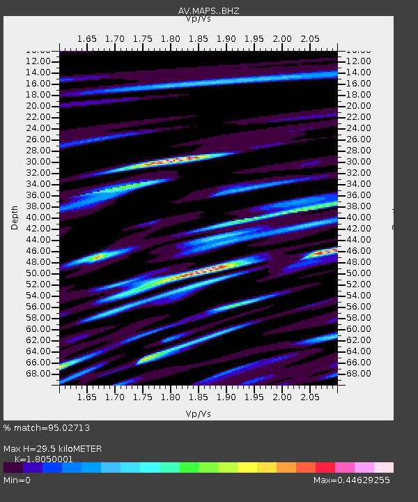
| Estimated Moho Depth: |
29.5 km |
| Estimated Crust Vp/Vs: |
1.81 |
| Assumed Crust Vp: |
3.943 km/s |
| Estimated Crust Vs: |
2.185 km/s |
| Estimated Crust Poisson's Ratio: |
0.28 |
|
| Radial Match: |
95.02713 % |
| Radial Bump: |
246 |
| Transverse Match: |
98.43306 % |
| Transverse Bump: |
116 |
| SOD ConfigId: |
26694651 |
| Insert Time: |
2022-02-19 04:22:47.057 +0000 |
| GWidth: |
2.5 |
| Max Bumps: |
400 |
| Tol: |
0.001 |
|

Signal To Noise
| Channel | StoN | STA | LTA |
| AV:MAPS: :BHZ:20220205T04:27:00.099989Z | 5.770431 | 4.3239545E-9 | 7.4932954E-10 |
| AV:MAPS: :BHN:20220205T04:27:00.099989Z | 6.801938 | 2.2868743E-8 | 3.3620922E-9 |
| AV:MAPS: :BHE:20220205T04:27:00.099989Z | 6.8076253 | 2.7591865E-8 | 4.0530823E-9 |
| Arrivals |
| Ps | 6.1 SECOND |
| PpPs | 21 SECOND |
| PsPs/PpSs | 27 SECOND |


