You are here: Home > Network List > US - United States National Seismic Network Stations List
> Station MNTX Cornudas Mountains, Texas, USA > Earthquake Result Viewer
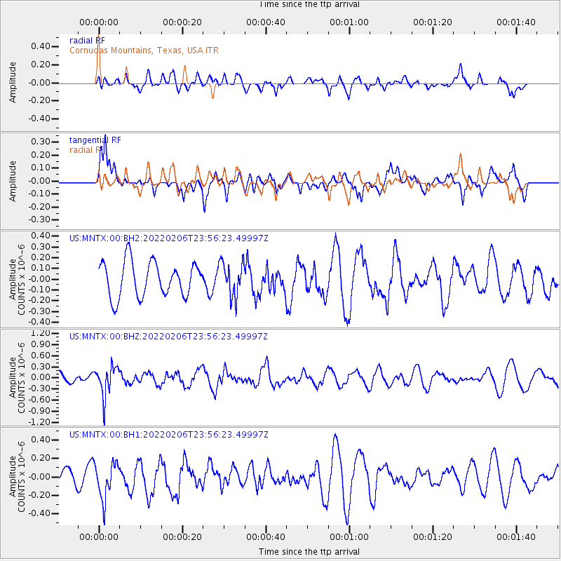
MNTX Cornudas Mountains, Texas, USA - Earthquake Result Viewer
*The percent match for this event was below the threshold and hence no stack was calculated.
| Earthquake location: |
Northern Chile |
| Earthquake latitude/longitude: |
-22.2/-68.7 |
| Earthquake time(UTC): |
2022/02/06 (037) 23:46:31 GMT |
| Earthquake Depth: |
104 km |
| Earthquake Magnitude: |
5.3 Mww |
| Earthquake Catalog/Contributor: |
NEIC PDE/us |
|
| Network: |
US United States National Seismic Network |
| Station: |
MNTX Cornudas Mountains, Texas, USA |
| Lat/Lon: |
31.70 N/105.38 W |
| Elevation: |
405 m |
|
| Distance: |
64.1 deg |
| Az: |
325.548 deg |
| Baz: |
142.044 deg |
| Ray Param: |
$rayparam |
*The percent match for this event was below the threshold and hence was not used in the summary stack. |
|
| Radial Match: |
48.991116 % |
| Radial Bump: |
400 |
| Transverse Match: |
63.87549 % |
| Transverse Bump: |
400 |
| SOD ConfigId: |
26694651 |
| Insert Time: |
2022-02-21 00:07:23.583 +0000 |
| GWidth: |
2.5 |
| Max Bumps: |
400 |
| Tol: |
0.001 |
|
Signal To Noise
| Channel | StoN | STA | LTA |
| US:MNTX:00:BHZ:20220206T23:56:23.49997Z | 2.9815304 | 3.9759192E-7 | 1.3335162E-7 |
| US:MNTX:00:BH1:20220206T23:56:23.49997Z | 2.683096 | 1.9341739E-7 | 7.2087396E-8 |
| US:MNTX:00:BH2:20220206T23:56:23.49997Z | 0.97867095 | 1.580801E-7 | 1.6152528E-7 |
| Arrivals |
| Ps | |
| PpPs | |
| PsPs/PpSs | |


