You are here: Home > Network List > GS - US Geological Survey Networks Stations List
> Station DEC09 Kile Street Surface Site > Earthquake Result Viewer
DEC09 Kile Street Surface Site - Earthquake Result Viewer
*The percent match for this event was below the threshold and hence no stack was calculated.
| Earthquake location: |
Ascension Island Region |
| Earthquake latitude/longitude: |
-10.4/-13.1 |
| Earthquake time(UTC): |
2022/02/10 (041) 10:27:32 GMT |
| Earthquake Depth: |
10 km |
| Earthquake Magnitude: |
5.5 Mww |
| Earthquake Catalog/Contributor: |
NEIC PDE/us |
|
| Network: |
GS US Geological Survey Networks |
| Station: |
DEC09 Kile Street Surface Site |
| Lat/Lon: |
39.87 N/88.92 W |
| Elevation: |
207 m |
|
| Distance: |
86.0 deg |
| Az: |
311.577 deg |
| Baz: |
107.017 deg |
| Ray Param: |
$rayparam |
*The percent match for this event was below the threshold and hence was not used in the summary stack. |
|
| Radial Match: |
52.230682 % |
| Radial Bump: |
400 |
| Transverse Match: |
51.325264 % |
| Transverse Bump: |
400 |
| SOD ConfigId: |
26694651 |
| Insert Time: |
2022-02-24 10:32:39.382 +0000 |
| GWidth: |
2.5 |
| Max Bumps: |
400 |
| Tol: |
0.001 |
|
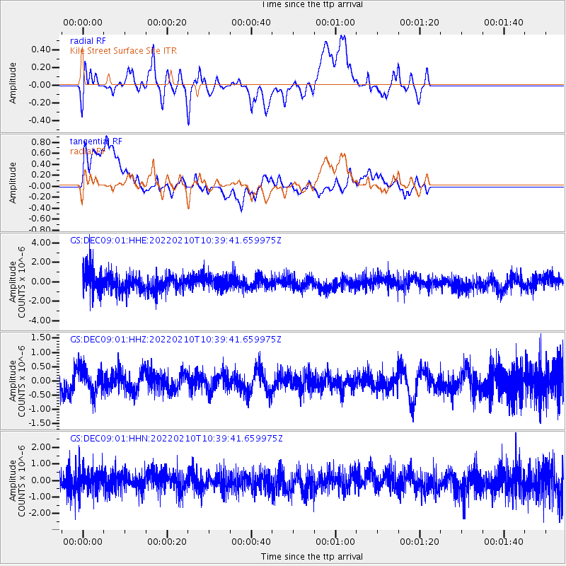
Signal To Noise
| Channel | StoN | STA | LTA |
| GS:DEC09:01:HHZ:20220210T10:39:41.659975Z | 0.6909719 | 4.3533285E-7 | 6.300297E-7 |
| GS:DEC09:01:HHN:20220210T10:39:41.659975Z | 0.71430707 | 6.766517E-7 | 9.472841E-7 |
| GS:DEC09:01:HHE:20220210T10:39:41.659975Z | 0.67375624 | 6.515534E-7 | 9.670462E-7 |
| Arrivals |
| Ps | |
| PpPs | |
| PsPs/PpSs | |


