You are here: Home > Network List > AK - Alaska Regional Network Stations List
> Station E27K Coleen River, AK, USA > Earthquake Result Viewer
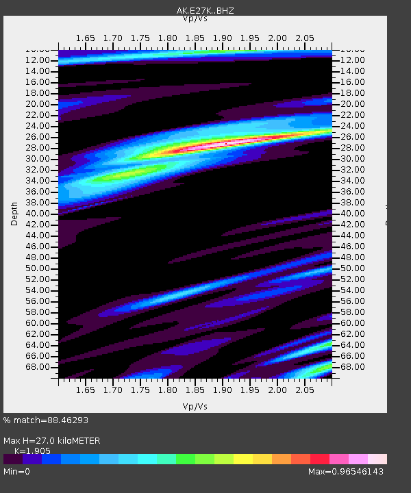
E27K Coleen River, AK, USA - Earthquake Result Viewer
| Earthquake location: |
South Of Mariana Islands |
| Earthquake latitude/longitude: |
11.8/144.3 |
| Earthquake time(UTC): |
2022/02/13 (044) 20:29:45 GMT |
| Earthquake Depth: |
10 km |
| Earthquake Magnitude: |
5.7 Mww |
| Earthquake Catalog/Contributor: |
NEIC PDE/us |
|
| Network: |
AK Alaska Regional Network |
| Station: |
E27K Coleen River, AK, USA |
| Lat/Lon: |
68.19 N/141.60 W |
| Elevation: |
654 m |
|
| Distance: |
73.2 deg |
| Az: |
22.05 deg |
| Baz: |
259.597 deg |
| Ray Param: |
0.053142842 |
| Estimated Moho Depth: |
27.0 km |
| Estimated Crust Vp/Vs: |
1.90 |
| Assumed Crust Vp: |
6.522 km/s |
| Estimated Crust Vs: |
3.423 km/s |
| Estimated Crust Poisson's Ratio: |
0.31 |
|
| Radial Match: |
88.46293 % |
| Radial Bump: |
400 |
| Transverse Match: |
79.79291 % |
| Transverse Bump: |
400 |
| SOD ConfigId: |
26694651 |
| Insert Time: |
2022-02-27 20:32:08.398 +0000 |
| GWidth: |
2.5 |
| Max Bumps: |
400 |
| Tol: |
0.001 |
|

Signal To Noise
| Channel | StoN | STA | LTA |
| AK:E27K: :BHZ:20220213T20:40:45.460013Z | 7.4709396 | 8.9020733E-7 | 1.19156006E-7 |
| AK:E27K: :BHN:20220213T20:40:45.460013Z | 0.76165116 | 8.616391E-8 | 1.1312779E-7 |
| AK:E27K: :BHE:20220213T20:40:45.460013Z | 4.3076234 | 3.9978298E-7 | 9.280824E-8 |
| Arrivals |
| Ps | 3.9 SECOND |
| PpPs | 12 SECOND |
| PsPs/PpSs | 16 SECOND |


