You are here: Home > Network List > AK - Alaska Regional Network Stations List
> Station J20K Nowitna River, AK, USA > Earthquake Result Viewer
J20K Nowitna River, AK, USA - Earthquake Result Viewer
| Earthquake location: |
South Of Mariana Islands |
| Earthquake latitude/longitude: |
11.8/144.3 |
| Earthquake time(UTC): |
2022/02/13 (044) 20:29:45 GMT |
| Earthquake Depth: |
10 km |
| Earthquake Magnitude: |
5.7 Mww |
| Earthquake Catalog/Contributor: |
NEIC PDE/us |
|
| Network: |
AK Alaska Regional Network |
| Station: |
J20K Nowitna River, AK, USA |
| Lat/Lon: |
64.18 N/154.15 W |
| Elevation: |
314 m |
|
| Distance: |
67.2 deg |
| Az: |
24.682 deg |
| Baz: |
249.004 deg |
| Ray Param: |
0.057089843 |
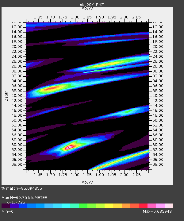
| Estimated Moho Depth: |
60.75 km |
| Estimated Crust Vp/Vs: |
1.77 |
| Assumed Crust Vp: |
6.566 km/s |
| Estimated Crust Vs: |
3.704 km/s |
| Estimated Crust Poisson's Ratio: |
0.27 |
|
| Radial Match: |
85.694855 % |
| Radial Bump: |
357 |
| Transverse Match: |
41.546658 % |
| Transverse Bump: |
400 |
| SOD ConfigId: |
26694651 |
| Insert Time: |
2022-02-27 20:33:04.570 +0000 |
| GWidth: |
2.5 |
| Max Bumps: |
400 |
| Tol: |
0.001 |
|

Signal To Noise
| Channel | StoN | STA | LTA |
| AK:J20K: :BHZ:20220213T20:40:08.900016Z | 7.192607 | 1.1093605E-6 | 1.542362E-7 |
| AK:J20K: :BHN:20220213T20:40:08.900016Z | 1.6180755 | 3.3048795E-7 | 2.0424754E-7 |
| AK:J20K: :BHE:20220213T20:40:08.900016Z | 2.5554578 | 3.9319912E-7 | 1.5386641E-7 |
| Arrivals |
| Ps | 7.5 SECOND |
| PpPs | 25 SECOND |
| PsPs/PpSs | 32 SECOND |


