You are here: Home > Network List > US - United States National Seismic Network Stations List
> Station HAWA Hanford, Washington, USA > Earthquake Result Viewer
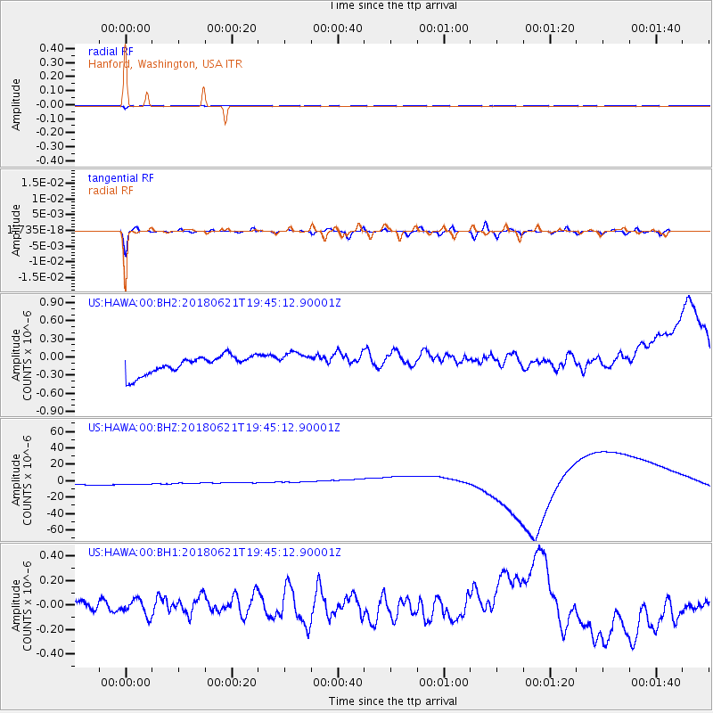
HAWA Hanford, Washington, USA - Earthquake Result Viewer
*The percent match for this event was below the threshold and hence no stack was calculated.
| Earthquake location: |
Tonga Islands Region |
| Earthquake latitude/longitude: |
-22.5/-174.9 |
| Earthquake time(UTC): |
2018/06/21 (172) 19:33:08 GMT |
| Earthquake Depth: |
4.8 km |
| Earthquake Magnitude: |
5.4 mb |
| Earthquake Catalog/Contributor: |
NEIC PDE/us |
|
| Network: |
US United States National Seismic Network |
| Station: |
HAWA Hanford, Washington, USA |
| Lat/Lon: |
46.39 N/119.53 W |
| Elevation: |
364 m |
|
| Distance: |
84.9 deg |
| Az: |
34.878 deg |
| Baz: |
229.8 deg |
| Ray Param: |
$rayparam |
*The percent match for this event was below the threshold and hence was not used in the summary stack. |
|
| Radial Match: |
95.07379 % |
| Radial Bump: |
400 |
| Transverse Match: |
73.3774 % |
| Transverse Bump: |
400 |
| SOD ConfigId: |
2709371 |
| Insert Time: |
2018-07-05 19:38:13.214 +0000 |
| GWidth: |
2.5 |
| Max Bumps: |
400 |
| Tol: |
0.001 |
|
Signal To Noise
| Channel | StoN | STA | LTA |
| US:HAWA:00:BHZ:20180621T19:45:12.90001Z | 0.92739415 | 1.1945482E-5 | 1.2880695E-5 |
| US:HAWA:00:BH1:20180621T19:45:12.90001Z | 1.2273171 | 6.801879E-8 | 5.5420717E-8 |
| US:HAWA:00:BH2:20180621T19:45:12.90001Z | 1.1254501 | 1.6702799E-7 | 1.4840995E-7 |
| Arrivals |
| Ps | |
| PpPs | |
| PsPs/PpSs | |


