You are here: Home > Network List > CC - Cascade Chain Volcano Monitoring Stations List
> Station LOO Loowit > Earthquake Result Viewer
LOO Loowit - Earthquake Result Viewer
| Earthquake location: |
South Of Mariana Islands |
| Earthquake latitude/longitude: |
11.8/144.3 |
| Earthquake time(UTC): |
2022/02/13 (044) 20:29:45 GMT |
| Earthquake Depth: |
10 km |
| Earthquake Magnitude: |
5.7 Mww |
| Earthquake Catalog/Contributor: |
NEIC PDE/us |
|
| Network: |
CC Cascade Chain Volcano Monitoring |
| Station: |
LOO Loowit |
| Lat/Lon: |
46.22 N/122.18 W |
| Elevation: |
1521 m |
|
| Distance: |
84.0 deg |
| Az: |
44.168 deg |
| Baz: |
280.669 deg |
| Ray Param: |
0.045784123 |
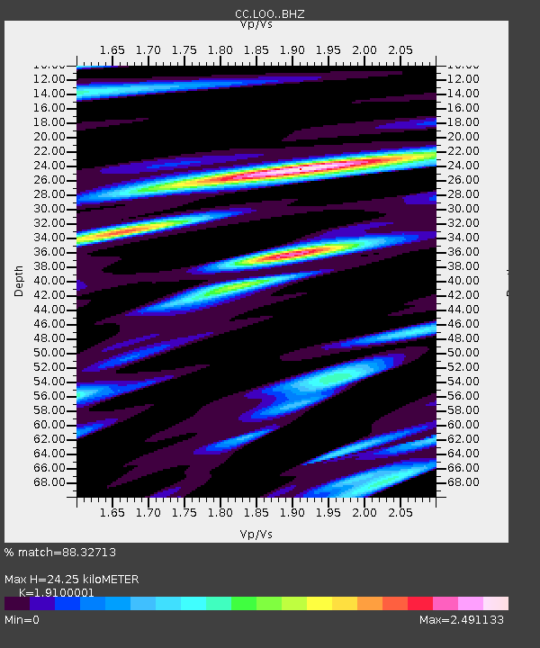
| Estimated Moho Depth: |
24.25 km |
| Estimated Crust Vp/Vs: |
1.91 |
| Assumed Crust Vp: |
6.566 km/s |
| Estimated Crust Vs: |
3.438 km/s |
| Estimated Crust Poisson's Ratio: |
0.31 |
|
| Radial Match: |
88.32713 % |
| Radial Bump: |
400 |
| Transverse Match: |
84.186615 % |
| Transverse Bump: |
400 |
| SOD ConfigId: |
26694651 |
| Insert Time: |
2022-02-27 20:40:51.889 +0000 |
| GWidth: |
2.5 |
| Max Bumps: |
400 |
| Tol: |
0.001 |
|

Signal To Noise
| Channel | StoN | STA | LTA |
| CC:LOO: :BHZ:20220213T20:41:44.600028Z | 4.6227875 | 8.4615357E-7 | 1.8303969E-7 |
| CC:LOO: :BHN:20220213T20:41:44.600028Z | 0.94256866 | 2.5874817E-7 | 2.7451387E-7 |
| CC:LOO: :BHE:20220213T20:41:44.600028Z | 1.7522342 | 4.0008064E-7 | 2.28326E-7 |
| Arrivals |
| Ps | 3.4 SECOND |
| PpPs | 10 SECOND |
| PsPs/PpSs | 14 SECOND |


