You are here: Home > Network List > XE05 - Sierra Nevada EarthScope Project- EarthScope Flex Array Stations List
> Station SNP66 SNP66 > Earthquake Result Viewer
SNP66 SNP66 - Earthquake Result Viewer
| Earthquake location: |
New Ireland Region, P.N.G. |
| Earthquake latitude/longitude: |
-4.5/153.5 |
| Earthquake time(UTC): |
2005/09/09 (252) 07:26:43 GMT |
| Earthquake Depth: |
90 km |
| Earthquake Magnitude: |
6.3 MB, 7.7 MW, 7.5 MW |
| Earthquake Catalog/Contributor: |
WHDF/NEIC |
|
| Network: |
XE Sierra Nevada EarthScope Project- EarthScope Flex Array |
| Station: |
SNP66 SNP66 |
| Lat/Lon: |
38.18 N/119.34 W |
| Elevation: |
2429 m |
|
| Distance: |
90.6 deg |
| Az: |
51.922 deg |
| Baz: |
264.716 deg |
| Ray Param: |
0.04164741 |
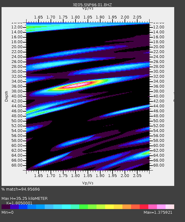
| Estimated Moho Depth: |
35.25 km |
| Estimated Crust Vp/Vs: |
1.81 |
| Assumed Crust Vp: |
6.279 km/s |
| Estimated Crust Vs: |
3.478 km/s |
| Estimated Crust Poisson's Ratio: |
0.28 |
|
| Radial Match: |
94.95696 % |
| Radial Bump: |
400 |
| Transverse Match: |
78.34096 % |
| Transverse Bump: |
400 |
| SOD ConfigId: |
268666 |
| Insert Time: |
2010-03-09 16:42:36.059 +0000 |
| GWidth: |
2.5 |
| Max Bumps: |
400 |
| Tol: |
0.001 |
|

Signal To Noise
| Channel | StoN | STA | LTA |
| XE:SNP66:01:BHZ:20050909T07:39:04.565022Z | 10.346786 | 9.966526E-7 | 9.6324854E-8 |
| XE:SNP66:01:BHN:20050909T07:39:04.565022Z | 1.0170612 | 1.0475254E-7 | 1.0299531E-7 |
| XE:SNP66:01:BHE:20050909T07:39:04.565022Z | 3.80923 | 4.3485088E-7 | 1.1415715E-7 |
| Arrivals |
| Ps | 4.6 SECOND |
| PpPs | 15 SECOND |
| PsPs/PpSs | 20 SECOND |


