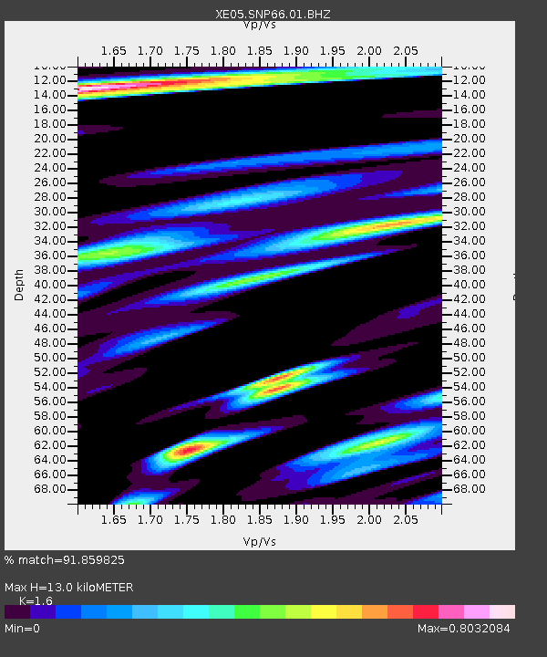
SNP66 SNP66 - Earthquake Result Viewer

Earthquake location: Fiji Islands Region
Earthquake latitude/longitude: -15.3/-178.6
Earthquake time(UTC): 2005/12/13 (347) 03:16:06 GMT
Earthquake Depth: 10 km
Earthquake Magnitude: 6.1 MB, 6.8 MS, 6.7 MW, 6.7 MW
Earthquake Catalog/Contributor: WHDF/NEIC
Network: XE Sierra Nevada EarthScope Project- EarthScope Flex Array
Station: SNP66 SNP66
Lat/Lon: 38.18 N/119.34 W
Elevation: 2429 m
Distance: 76.8 deg
Az: 44.065 deg
Baz: 238.402 deg
Ray Param: 0.05074027
Estimated Moho Depth: 13.0 km
Estimated Crust Vp/Vs: 1.60
Assumed Crust Vp: 6.279 km/s
Estimated Crust Vs: 3.924 km/s
Estimated Crust Poisson's Ratio: 0.18
Radial Match: 91.859825 %
Radial Bump: 400
Transverse Match: 87.31804 %
Transverse Bump: 400
SOD ConfigId: 268666
Insert Time: 2010-03-09 16:42:44.529 +0000
GWidth: 2.5
Max Bumps: 400
Tol: 0.001

Signal To Noise

ChannelStoNSTALTA
XE:SNP66:01:BHZ:20051213T03:27:26.864009Z6.02843331.0092486E-61.6741474E-7
XE:SNP66:01:BHN:20051213T03:27:26.864009Z1.31574132.4940837E-71.8955728E-7
XE:SNP66:01:BHE:20051213T03:27:26.864009Z3.37726525.153431E-71.5259185E-7
Arrivals
Ps1.3 SECOND
PpPs5.2 SECOND
PsPs/PpSs6.5 SECOND