You are here: Home > Network List > TD - TransAlta Monitoring Network Stations List
> Station TD009 Z > Earthquake Result Viewer
TD009 Z - Earthquake Result Viewer
| Earthquake location: |
South Of Mariana Islands |
| Earthquake latitude/longitude: |
11.8/144.3 |
| Earthquake time(UTC): |
2022/02/13 (044) 20:29:45 GMT |
| Earthquake Depth: |
10 km |
| Earthquake Magnitude: |
5.7 Mww |
| Earthquake Catalog/Contributor: |
NEIC PDE/us |
|
| Network: |
TD TransAlta Monitoring Network |
| Station: |
TD009 Z |
| Lat/Lon: |
52.32 N/116.32 W |
| Elevation: |
1335 m |
|
| Distance: |
86.4 deg |
| Az: |
37.358 deg |
| Baz: |
284.537 deg |
| Ray Param: |
0.044061642 |
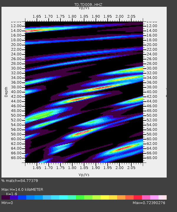
| Estimated Moho Depth: |
14.0 km |
| Estimated Crust Vp/Vs: |
1.60 |
| Assumed Crust Vp: |
6.142 km/s |
| Estimated Crust Vs: |
3.839 km/s |
| Estimated Crust Poisson's Ratio: |
0.18 |
|
| Radial Match: |
84.77379 % |
| Radial Bump: |
400 |
| Transverse Match: |
63.32147 % |
| Transverse Bump: |
400 |
| SOD ConfigId: |
26694651 |
| Insert Time: |
2022-02-27 20:51:04.643 +0000 |
| GWidth: |
2.5 |
| Max Bumps: |
400 |
| Tol: |
0.001 |
|

Signal To Noise
| Channel | StoN | STA | LTA |
| TD:TD009: :HHZ:20220213T20:41:56.660025Z | 7.111455 | 8.377211E-7 | 1.1779883E-7 |
| TD:TD009: :HH1:20220213T20:41:56.660025Z | 0.70235604 | 8.796226E-8 | 1.2523886E-7 |
| TD:TD009: :HH2:20220213T20:41:56.660025Z | 3.211034 | 3.6005707E-7 | 1.1213119E-7 |
| Arrivals |
| Ps | 1.4 SECOND |
| PpPs | 5.8 SECOND |
| PsPs/PpSs | 7.2 SECOND |


