You are here: Home > Network List > IU - Global Seismograph Network (GSN - IRIS/USGS) Stations List
> Station XMAS Kiritimati Island, Republic of Kiribati > Earthquake Result Viewer
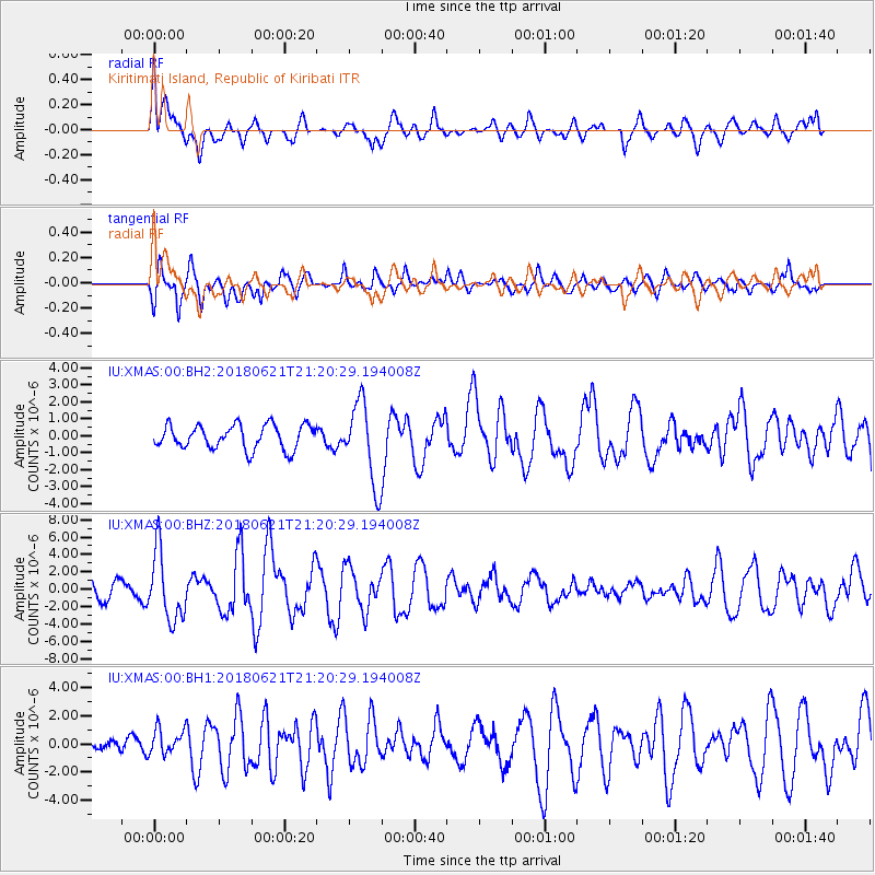
XMAS Kiritimati Island, Republic of Kiribati - Earthquake Result Viewer
*The percent match for this event was below the threshold and hence no stack was calculated.
| Earthquake location: |
Vanuatu Islands |
| Earthquake latitude/longitude: |
-17.8/168.0 |
| Earthquake time(UTC): |
2018/06/21 (172) 21:13:32 GMT |
| Earthquake Depth: |
22 km |
| Earthquake Magnitude: |
6.1 Mww |
| Earthquake Catalog/Contributor: |
NEIC PDE/us |
|
| Network: |
IU Global Seismograph Network (GSN - IRIS/USGS) |
| Station: |
XMAS Kiritimati Island, Republic of Kiribati |
| Lat/Lon: |
2.04 N/157.45 W |
| Elevation: |
20 m |
|
| Distance: |
39.3 deg |
| Az: |
63.361 deg |
| Baz: |
238.434 deg |
| Ray Param: |
$rayparam |
*The percent match for this event was below the threshold and hence was not used in the summary stack. |
|
| Radial Match: |
65.320206 % |
| Radial Bump: |
400 |
| Transverse Match: |
69.55252 % |
| Transverse Bump: |
400 |
| SOD ConfigId: |
2709371 |
| Insert Time: |
2018-07-05 21:21:47.694 +0000 |
| GWidth: |
2.5 |
| Max Bumps: |
400 |
| Tol: |
0.001 |
|
Signal To Noise
| Channel | StoN | STA | LTA |
| IU:XMAS:00:BHZ:20180621T21:20:29.194008Z | 4.3421044 | 3.9198408E-6 | 9.027514E-7 |
| IU:XMAS:00:BH1:20180621T21:20:29.194008Z | 1.088467 | 9.05268E-7 | 8.3169084E-7 |
| IU:XMAS:00:BH2:20180621T21:20:29.194008Z | 3.3431494 | 2.37552E-6 | 7.105635E-7 |
| Arrivals |
| Ps | |
| PpPs | |
| PsPs/PpSs | |


