You are here: Home > Network List > UW - Pacific Northwest Regional Seismic Network Stations List
> Station SLF Sugar Loaf > Earthquake Result Viewer
SLF Sugar Loaf - Earthquake Result Viewer
| Earthquake location: |
South Of Mariana Islands |
| Earthquake latitude/longitude: |
11.8/144.3 |
| Earthquake time(UTC): |
2022/02/13 (044) 20:29:45 GMT |
| Earthquake Depth: |
10 km |
| Earthquake Magnitude: |
5.7 Mww |
| Earthquake Catalog/Contributor: |
NEIC PDE/us |
|
| Network: |
UW Pacific Northwest Regional Seismic Network |
| Station: |
SLF Sugar Loaf |
| Lat/Lon: |
47.76 N/120.53 W |
| Elevation: |
1739 m |
|
| Distance: |
84.8 deg |
| Az: |
42.432 deg |
| Baz: |
281.707 deg |
| Ray Param: |
0.045214616 |
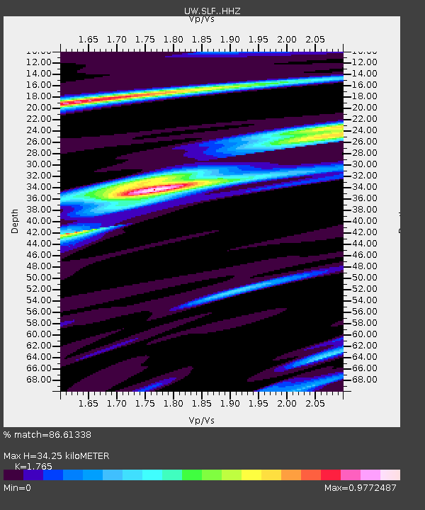
| Estimated Moho Depth: |
34.25 km |
| Estimated Crust Vp/Vs: |
1.76 |
| Assumed Crust Vp: |
6.597 km/s |
| Estimated Crust Vs: |
3.738 km/s |
| Estimated Crust Poisson's Ratio: |
0.26 |
|
| Radial Match: |
86.61338 % |
| Radial Bump: |
400 |
| Transverse Match: |
70.66209 % |
| Transverse Bump: |
400 |
| SOD ConfigId: |
26694651 |
| Insert Time: |
2022-02-27 20:55:37.696 +0000 |
| GWidth: |
2.5 |
| Max Bumps: |
400 |
| Tol: |
0.001 |
|

Signal To Noise
| Channel | StoN | STA | LTA |
| UW:SLF: :HHZ:20220213T20:41:48.700003Z | 7.137372 | 7.966666E-7 | 1.1161903E-7 |
| UW:SLF: :HHN:20220213T20:41:48.700003Z | 1.165409 | 1.6991403E-7 | 1.4579777E-7 |
| UW:SLF: :HHE:20220213T20:41:48.700003Z | 2.74726 | 3.35517E-7 | 1.2212786E-7 |
| Arrivals |
| Ps | 4.1 SECOND |
| PpPs | 14 SECOND |
| PsPs/PpSs | 18 SECOND |


