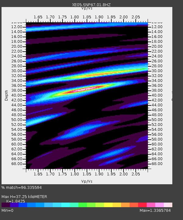
SNP67 SNP67 - Earthquake Result Viewer

Earthquake location: Tonga Islands
Earthquake latitude/longitude: -20.2/-174.1
Earthquake time(UTC): 2006/05/03 (123) 15:26:40 GMT
Earthquake Depth: 55 km
Earthquake Magnitude: 7.2 MB, 7.8 MS, 7.9 MW, 7.9 MW
Earthquake Catalog/Contributor: WHDF/NEIC
Network: XE Sierra Nevada EarthScope Project- EarthScope Flex Array
Station: SNP67 SNP67
Lat/Lon: 38.28 N/119.15 W
Elevation: 2277 m
Distance: 77.7 deg
Az: 41.265 deg
Baz: 231.925 deg
Ray Param: 0.050022323
Estimated Moho Depth: 37.25 km
Estimated Crust Vp/Vs: 1.84
Assumed Crust Vp: 6.279 km/s
Estimated Crust Vs: 3.408 km/s
Estimated Crust Poisson's Ratio: 0.29
Radial Match: 96.335594 %
Radial Bump: 400
Transverse Match: 90.3031 %
Transverse Bump: 400
SOD ConfigId: 268666
Insert Time: 2010-03-09 16:46:03.014 +0000
GWidth: 2.5
Max Bumps: 400
Tol: 0.001

Signal To Noise

ChannelStoNSTALTA
XE:SNP67:01:BHZ:20060503T15:38:00.290Z5.40628671.3367497E-62.4725838E-7
XE:SNP67:01:BHN:20060503T15:38:00.290Z0.95763082.363176E-72.4677317E-7
XE:SNP67:01:BHE:20060503T15:38:00.290Z1.81458444.8808823E-72.6898073E-7
Arrivals
Ps5.1 SECOND
PpPs16 SECOND
PsPs/PpSs22 SECOND