You are here: Home > Network List > UW - Pacific Northwest Regional Seismic Network Stations List
> Station HOOD Mt Hood Meadows, OR CREST BB SMO > Earthquake Result Viewer
HOOD Mt Hood Meadows, OR CREST BB SMO - Earthquake Result Viewer
*The percent match for this event was below the threshold and hence no stack was calculated.
| Earthquake location: |
Jan Mayen Island Region |
| Earthquake latitude/longitude: |
70.7/-14.4 |
| Earthquake time(UTC): |
2022/02/14 (045) 20:28:21 GMT |
| Earthquake Depth: |
10 km |
| Earthquake Magnitude: |
5.7 Mww |
| Earthquake Catalog/Contributor: |
NEIC PDE/us |
|
| Network: |
UW Pacific Northwest Regional Seismic Network |
| Station: |
HOOD Mt Hood Meadows, OR CREST BB SMO |
| Lat/Lon: |
45.32 N/121.65 W |
| Elevation: |
1520 m |
|
| Distance: |
53.2 deg |
| Az: |
302.736 deg |
| Baz: |
23.315 deg |
| Ray Param: |
$rayparam |
*The percent match for this event was below the threshold and hence was not used in the summary stack. |
|
| Radial Match: |
31.1104 % |
| Radial Bump: |
400 |
| Transverse Match: |
49.075706 % |
| Transverse Bump: |
400 |
| SOD ConfigId: |
26694651 |
| Insert Time: |
2022-02-28 20:57:34.277 +0000 |
| GWidth: |
2.5 |
| Max Bumps: |
400 |
| Tol: |
0.001 |
|
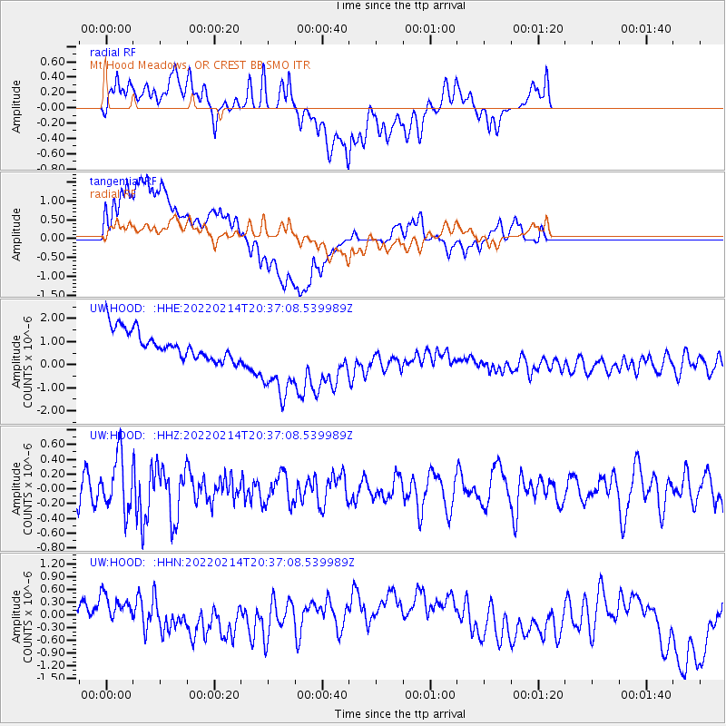
Signal To Noise
| Channel | StoN | STA | LTA |
| UW:HOOD: :HHZ:20220214T20:37:08.539989Z | 1.8011651 | 3.7321442E-7 | 2.0720721E-7 |
| UW:HOOD: :HHN:20220214T20:37:08.539989Z | 1.0219764 | 6.516042E-7 | 6.375923E-7 |
| UW:HOOD: :HHE:20220214T20:37:08.539989Z | 2.9133832 | 1.7806672E-6 | 6.112025E-7 |
| Arrivals |
| Ps | |
| PpPs | |
| PsPs/PpSs | |


