You are here: Home > Network List > UW - Pacific Northwest Regional Seismic Network Stations List
> Station UMAT Pilot Rock, OR, USA > Earthquake Result Viewer
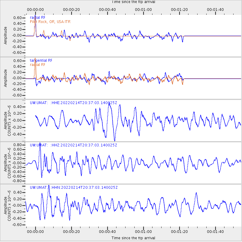
UMAT Pilot Rock, OR, USA - Earthquake Result Viewer
*The percent match for this event was below the threshold and hence no stack was calculated.
| Earthquake location: |
Jan Mayen Island Region |
| Earthquake latitude/longitude: |
70.7/-14.4 |
| Earthquake time(UTC): |
2022/02/14 (045) 20:28:21 GMT |
| Earthquake Depth: |
10 km |
| Earthquake Magnitude: |
5.7 Mww |
| Earthquake Catalog/Contributor: |
NEIC PDE/us |
|
| Network: |
UW Pacific Northwest Regional Seismic Network |
| Station: |
UMAT Pilot Rock, OR, USA |
| Lat/Lon: |
45.29 N/118.96 W |
| Elevation: |
1318 m |
|
| Distance: |
52.5 deg |
| Az: |
300.535 deg |
| Baz: |
23.894 deg |
| Ray Param: |
$rayparam |
*The percent match for this event was below the threshold and hence was not used in the summary stack. |
|
| Radial Match: |
61.414154 % |
| Radial Bump: |
375 |
| Transverse Match: |
53.806137 % |
| Transverse Bump: |
338 |
| SOD ConfigId: |
26694651 |
| Insert Time: |
2022-02-28 20:58:18.506 +0000 |
| GWidth: |
2.5 |
| Max Bumps: |
400 |
| Tol: |
0.001 |
|
Signal To Noise
| Channel | StoN | STA | LTA |
| UW:UMAT: :HHZ:20220214T20:37:03.140025Z | 2.6542482 | 3.7874568E-7 | 1.4269415E-7 |
| UW:UMAT: :HHN:20220214T20:37:03.140025Z | 1.8573443 | 1.994668E-7 | 1.07393554E-7 |
| UW:UMAT: :HHE:20220214T20:37:03.140025Z | 1.2176341 | 1.4550068E-7 | 1.1949459E-7 |
| Arrivals |
| Ps | |
| PpPs | |
| PsPs/PpSs | |


