You are here: Home > Network List > IW - Intermountain West Stations List
> Station MOOW Moose Ponds, Wyoming, USA > Earthquake Result Viewer
MOOW Moose Ponds, Wyoming, USA - Earthquake Result Viewer
*The percent match for this event was below the threshold and hence no stack was calculated.
| Earthquake location: |
Central Mid-Atlantic Ridge |
| Earthquake latitude/longitude: |
-0.5/-20.0 |
| Earthquake time(UTC): |
2022/02/12 (043) 20:48:54 GMT |
| Earthquake Depth: |
10 km |
| Earthquake Magnitude: |
5.5 Mww |
| Earthquake Catalog/Contributor: |
NEIC PDE/us |
|
| Network: |
IW Intermountain West |
| Station: |
MOOW Moose Ponds, Wyoming, USA |
| Lat/Lon: |
43.75 N/110.74 W |
| Elevation: |
2128 m |
|
| Distance: |
90.9 deg |
| Az: |
313.554 deg |
| Baz: |
89.83 deg |
| Ray Param: |
$rayparam |
*The percent match for this event was below the threshold and hence was not used in the summary stack. |
|
| Radial Match: |
51.65268 % |
| Radial Bump: |
400 |
| Transverse Match: |
35.955696 % |
| Transverse Bump: |
400 |
| SOD ConfigId: |
26694651 |
| Insert Time: |
2022-03-02 04:42:42.804 +0000 |
| GWidth: |
2.5 |
| Max Bumps: |
400 |
| Tol: |
0.001 |
|
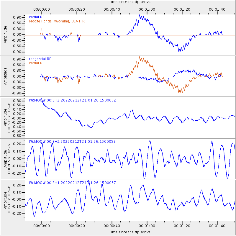
Signal To Noise
| Channel | StoN | STA | LTA |
| IW:MOOW:00:BHZ:20220212T21:01:26.150005Z | 1.1095876 | 1.5339943E-7 | 1.3824906E-7 |
| IW:MOOW:00:BH1:20220212T21:01:26.150005Z | 2.2482243 | 2.0047783E-7 | 8.917163E-8 |
| IW:MOOW:00:BH2:20220212T21:01:26.150005Z | 1.161104 | 3.475379E-7 | 2.9931678E-7 |
| Arrivals |
| Ps | |
| PpPs | |
| PsPs/PpSs | |


