You are here: Home > Network List > XE05 - Sierra Nevada EarthScope Project- EarthScope Flex Array Stations List
> Station SNP71 SNP71 > Earthquake Result Viewer
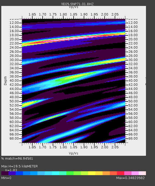
SNP71 SNP71 - Earthquake Result Viewer
| Earthquake location: |
Rat Islands, Aleutian Islands |
| Earthquake latitude/longitude: |
51.2/179.4 |
| Earthquake time(UTC): |
2005/06/14 (165) 17:10:16 GMT |
| Earthquake Depth: |
51 km |
| Earthquake Magnitude: |
6.0 MB, 6.8 MW, 6.6 MW |
| Earthquake Catalog/Contributor: |
WHDF/NEIC |
|
| Network: |
XE Sierra Nevada EarthScope Project- EarthScope Flex Array |
| Station: |
SNP71 SNP71 |
| Lat/Lon: |
37.64 N/120.40 W |
| Elevation: |
157 m |
|
| Distance: |
43.9 deg |
| Az: |
83.746 deg |
| Baz: |
308.065 deg |
| Ray Param: |
0.07213724 |
| Estimated Moho Depth: |
19.5 km |
| Estimated Crust Vp/Vs: |
1.83 |
| Assumed Crust Vp: |
6.391 km/s |
| Estimated Crust Vs: |
3.492 km/s |
| Estimated Crust Poisson's Ratio: |
0.29 |
|
| Radial Match: |
96.94581 % |
| Radial Bump: |
220 |
| Transverse Match: |
91.47167 % |
| Transverse Bump: |
400 |
| SOD ConfigId: |
268666 |
| Insert Time: |
2010-03-09 16:48:43.426 +0000 |
| GWidth: |
2.5 |
| Max Bumps: |
400 |
| Tol: |
0.001 |
|

Signal To Noise
| Channel | StoN | STA | LTA |
| XE:SNP71:01:BHZ:20050614T17:17:47.439011Z | 15.035565 | 1.411271E-6 | 9.3862184E-8 |
| XE:SNP71:01:BHN:20050614T17:17:47.439011Z | 5.7676277 | 5.356777E-7 | 9.287661E-8 |
| XE:SNP71:01:BHE:20050614T17:17:47.439011Z | 6.5329576 | 7.0258284E-7 | 1.0754437E-7 |
| Arrivals |
| Ps | 2.7 SECOND |
| PpPs | 8.1 SECOND |
| PsPs/PpSs | 11 SECOND |


