You are here: Home > Network List > IW - Intermountain West Stations List
> Station MOOW Moose Ponds, Wyoming, USA > Earthquake Result Viewer
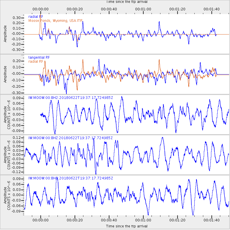
MOOW Moose Ponds, Wyoming, USA - Earthquake Result Viewer
*The percent match for this event was below the threshold and hence no stack was calculated.
| Earthquake location: |
Solomon Islands |
| Earthquake latitude/longitude: |
-10.0/161.7 |
| Earthquake time(UTC): |
2018/06/22 (173) 19:24:30 GMT |
| Earthquake Depth: |
43 km |
| Earthquake Magnitude: |
5.4 Mww |
| Earthquake Catalog/Contributor: |
NEIC PDE/us |
|
| Network: |
IW Intermountain West |
| Station: |
MOOW Moose Ponds, Wyoming, USA |
| Lat/Lon: |
43.75 N/110.74 W |
| Elevation: |
2128 m |
|
| Distance: |
95.1 deg |
| Az: |
46.633 deg |
| Baz: |
261.12 deg |
| Ray Param: |
$rayparam |
*The percent match for this event was below the threshold and hence was not used in the summary stack. |
|
| Radial Match: |
47.047287 % |
| Radial Bump: |
400 |
| Transverse Match: |
52.40174 % |
| Transverse Bump: |
400 |
| SOD ConfigId: |
2738091 |
| Insert Time: |
2018-07-06 19:27:01.771 +0000 |
| GWidth: |
2.5 |
| Max Bumps: |
400 |
| Tol: |
0.001 |
|
Signal To Noise
| Channel | StoN | STA | LTA |
| IW:MOOW:00:BHZ:20180622T19:37:17.724985Z | 1.0615531 | 4.402325E-8 | 4.1470603E-8 |
| IW:MOOW:00:BH1:20180622T19:37:17.724985Z | 1.1866388 | 3.619212E-8 | 3.049969E-8 |
| IW:MOOW:00:BH2:20180622T19:37:17.724985Z | 1.1953087 | 4.6650715E-8 | 3.9028173E-8 |
| Arrivals |
| Ps | |
| PpPs | |
| PsPs/PpSs | |


