You are here: Home > Network List > XE05 - Sierra Nevada EarthScope Project- EarthScope Flex Array Stations List
> Station SNP71 SNP71 > Earthquake Result Viewer
SNP71 SNP71 - Earthquake Result Viewer
| Earthquake location: |
Chile-Bolivia Border Region |
| Earthquake latitude/longitude: |
-22.3/-67.9 |
| Earthquake time(UTC): |
2005/11/17 (321) 19:26:56 GMT |
| Earthquake Depth: |
163 km |
| Earthquake Magnitude: |
6.0 MB, 6.9 MW, 6.8 MW |
| Earthquake Catalog/Contributor: |
WHDF/NEIC |
|
| Network: |
XE Sierra Nevada EarthScope Project- EarthScope Flex Array |
| Station: |
SNP71 SNP71 |
| Lat/Lon: |
37.64 N/120.40 W |
| Elevation: |
157 m |
|
| Distance: |
77.4 deg |
| Az: |
319.805 deg |
| Baz: |
131.163 deg |
| Ray Param: |
0.04992341 |
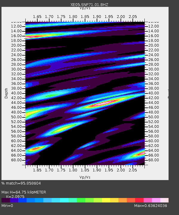
| Estimated Moho Depth: |
64.75 km |
| Estimated Crust Vp/Vs: |
2.10 |
| Assumed Crust Vp: |
6.391 km/s |
| Estimated Crust Vs: |
3.047 km/s |
| Estimated Crust Poisson's Ratio: |
0.35 |
|
| Radial Match: |
95.858604 % |
| Radial Bump: |
394 |
| Transverse Match: |
85.756226 % |
| Transverse Bump: |
400 |
| SOD ConfigId: |
268666 |
| Insert Time: |
2010-03-09 16:49:21.965 +0000 |
| GWidth: |
2.5 |
| Max Bumps: |
400 |
| Tol: |
0.001 |
|

Signal To Noise
| Channel | StoN | STA | LTA |
| XE:SNP71:01:BHZ:20051117T19:38:02.588997Z | 55.852093 | 6.0987527E-6 | 1.091947E-7 |
| XE:SNP71:01:BHN:20051117T19:38:02.588997Z | 6.910303 | 1.5884367E-6 | 2.2986498E-7 |
| XE:SNP71:01:BHE:20051117T19:38:02.588997Z | 9.480126 | 1.7820007E-6 | 1.8797225E-7 |
| Arrivals |
| Ps | 11 SECOND |
| PpPs | 31 SECOND |
| PsPs/PpSs | 42 SECOND |


