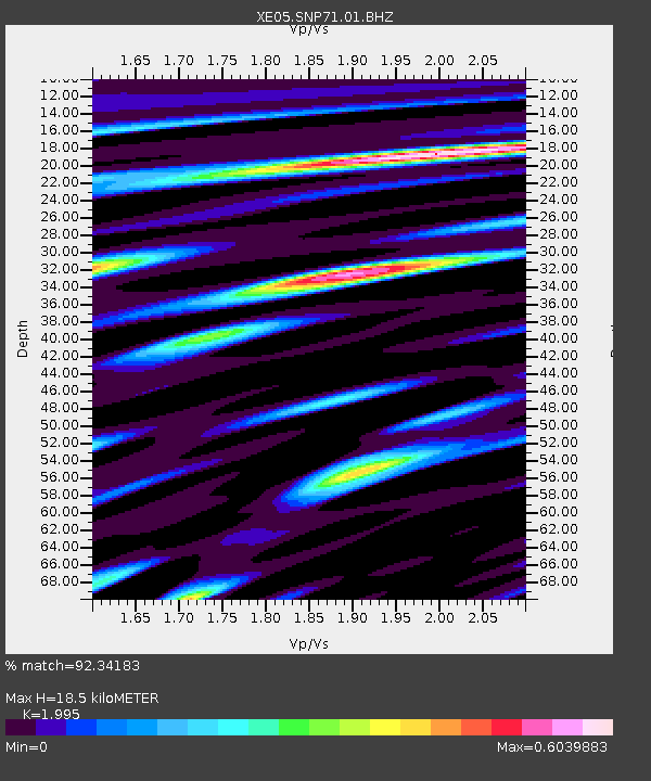
SNP71 SNP71 - Earthquake Result Viewer

Earthquake location: Rat Islands, Aleutian Islands
Earthquake latitude/longitude: 52.2/176.2
Earthquake time(UTC): 2006/06/27 (178) 02:39:35 GMT
Earthquake Depth: 34 km
Earthquake Magnitude: 5.6 MB, 6.0 MS, 6.2 MW, 6.2 MW
Earthquake Catalog/Contributor: WHDF/NEIC
Network: XE Sierra Nevada EarthScope Project- EarthScope Flex Array
Station: SNP71 SNP71
Lat/Lon: 37.64 N/120.40 W
Elevation: 157 m
Distance: 45.7 deg
Az: 82.439 deg
Baz: 309.78 deg
Ray Param: 0.0710154
Estimated Moho Depth: 18.5 km
Estimated Crust Vp/Vs: 2.00
Assumed Crust Vp: 6.391 km/s
Estimated Crust Vs: 3.203 km/s
Estimated Crust Poisson's Ratio: 0.33
Radial Match: 92.34183 %
Radial Bump: 400
Transverse Match: 83.862206 %
Transverse Bump: 400
SOD ConfigId: 268666
Insert Time: 2010-03-09 16:49:49.166 +0000
GWidth: 2.5
Max Bumps: 400
Tol: 0.001

Signal To Noise

ChannelStoNSTALTA
XE:SNP71:01:BHZ:20060627T02:47:22.720012Z8.3431984.2961253E-75.1492545E-8
XE:SNP71:01:BHN:20060627T02:47:22.720012Z2.79796242.0340615E-77.269795E-8
XE:SNP71:01:BHE:20060627T02:47:22.720012Z1.67875061.5157083E-79.028787E-8
Arrivals
Ps3.0 SECOND
PpPs8.2 SECOND
PsPs/PpSs11 SECOND