You are here: Home > Network List > AV - Alaska Volcano Observatory Stations List
> Station AMKA Regional Station, Amchitka Island, Alaska > Earthquake Result Viewer
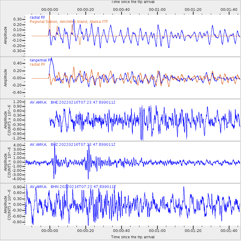
AMKA Regional Station, Amchitka Island, Alaska - Earthquake Result Viewer
*The percent match for this event was below the threshold and hence no stack was calculated.
| Earthquake location: |
Guatemala |
| Earthquake latitude/longitude: |
14.2/-91.3 |
| Earthquake time(UTC): |
2022/02/16 (047) 07:12:25 GMT |
| Earthquake Depth: |
84 km |
| Earthquake Magnitude: |
6.2 mww |
| Earthquake Catalog/Contributor: |
NEIC PDE/us |
|
| Network: |
AV Alaska Volcano Observatory |
| Station: |
AMKA Regional Station, Amchitka Island, Alaska |
| Lat/Lon: |
51.38 N/179.30 E |
| Elevation: |
116 m |
|
| Distance: |
78.7 deg |
| Az: |
320.274 deg |
| Baz: |
81.508 deg |
| Ray Param: |
$rayparam |
*The percent match for this event was below the threshold and hence was not used in the summary stack. |
|
| Radial Match: |
56.54871 % |
| Radial Bump: |
400 |
| Transverse Match: |
53.803207 % |
| Transverse Bump: |
400 |
| SOD ConfigId: |
26694651 |
| Insert Time: |
2022-03-02 07:17:46.867 +0000 |
| GWidth: |
2.5 |
| Max Bumps: |
400 |
| Tol: |
0.001 |
|
Signal To Noise
| Channel | StoN | STA | LTA |
| AV:AMKA: :BHZ:20220216T07:23:47.899011Z | 4.7913017 | 1.4173024E-6 | 2.9580738E-7 |
| AV:AMKA: :BHN:20220216T07:23:47.899011Z | 1.0904924 | 3.86296E-7 | 3.5423997E-7 |
| AV:AMKA: :BHE:20220216T07:23:47.899011Z | 0.91744643 | 2.9816786E-7 | 3.249976E-7 |
| Arrivals |
| Ps | |
| PpPs | |
| PsPs/PpSs | |


