You are here: Home > Network List > AV - Alaska Volcano Observatory Stations List
> Station SPCR Ckakachatna River, Mount Spurr, Alaska > Earthquake Result Viewer
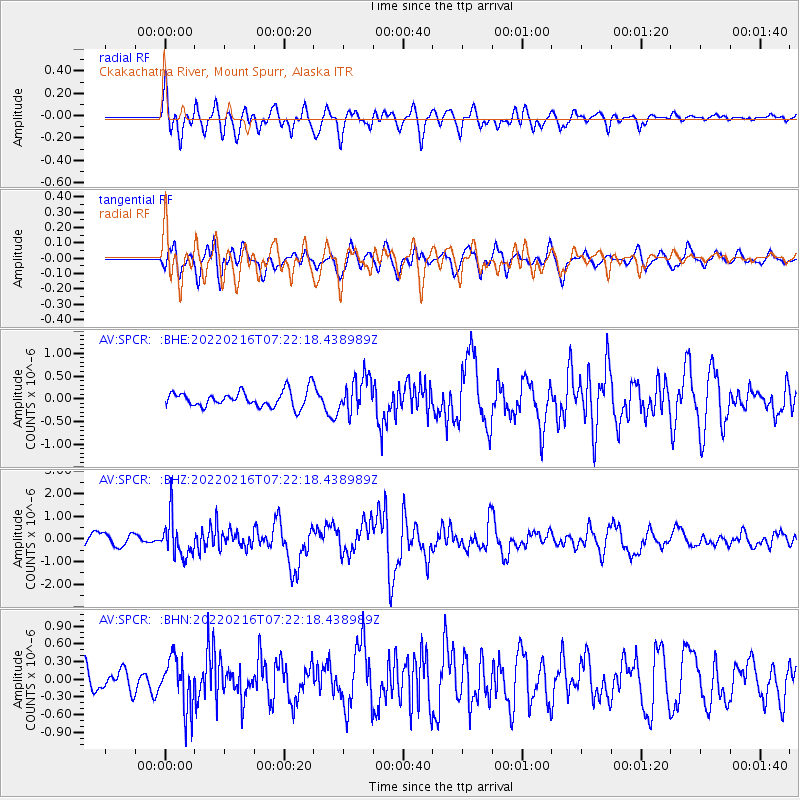
SPCR Ckakachatna River, Mount Spurr, Alaska - Earthquake Result Viewer
*The percent match for this event was below the threshold and hence no stack was calculated.
| Earthquake location: |
Guatemala |
| Earthquake latitude/longitude: |
14.2/-91.3 |
| Earthquake time(UTC): |
2022/02/16 (047) 07:12:25 GMT |
| Earthquake Depth: |
84 km |
| Earthquake Magnitude: |
6.2 mww |
| Earthquake Catalog/Contributor: |
NEIC PDE/us |
|
| Network: |
AV Alaska Volcano Observatory |
| Station: |
SPCR Ckakachatna River, Mount Spurr, Alaska |
| Lat/Lon: |
61.20 N/152.21 W |
| Elevation: |
984 m |
|
| Distance: |
63.8 deg |
| Az: |
331.861 deg |
| Baz: |
109.164 deg |
| Ray Param: |
$rayparam |
*The percent match for this event was below the threshold and hence was not used in the summary stack. |
|
| Radial Match: |
74.00028 % |
| Radial Bump: |
400 |
| Transverse Match: |
68.253815 % |
| Transverse Bump: |
400 |
| SOD ConfigId: |
26694651 |
| Insert Time: |
2022-03-02 07:19:13.273 +0000 |
| GWidth: |
2.5 |
| Max Bumps: |
400 |
| Tol: |
0.001 |
|
Signal To Noise
| Channel | StoN | STA | LTA |
| AV:SPCR: :BHZ:20220216T07:22:18.438989Z | 3.6607814 | 8.6655854E-7 | 2.367141E-7 |
| AV:SPCR: :BHN:20220216T07:22:18.438989Z | 2.2767494 | 4.266768E-7 | 1.8740613E-7 |
| AV:SPCR: :BHE:20220216T07:22:18.438989Z | 2.1853437 | 3.903691E-7 | 1.7863053E-7 |
| Arrivals |
| Ps | |
| PpPs | |
| PsPs/PpSs | |


