You are here: Home > Network List > GT - Global Telemetered Seismograph Network (USAF/USGS) Stations List
> Station PLCA Paso Flores, Argentina > Earthquake Result Viewer
PLCA Paso Flores, Argentina - Earthquake Result Viewer
| Earthquake location: |
Guatemala |
| Earthquake latitude/longitude: |
14.2/-91.3 |
| Earthquake time(UTC): |
2022/02/16 (047) 07:12:25 GMT |
| Earthquake Depth: |
84 km |
| Earthquake Magnitude: |
6.2 mww |
| Earthquake Catalog/Contributor: |
NEIC PDE/us |
|
| Network: |
GT Global Telemetered Seismograph Network (USAF/USGS) |
| Station: |
PLCA Paso Flores, Argentina |
| Lat/Lon: |
40.73 S/70.55 W |
| Elevation: |
1080 m |
|
| Distance: |
57.9 deg |
| Az: |
161.48 deg |
| Baz: |
336.084 deg |
| Ray Param: |
0.062935166 |
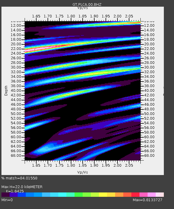
| Estimated Moho Depth: |
22.0 km |
| Estimated Crust Vp/Vs: |
1.64 |
| Assumed Crust Vp: |
6.597 km/s |
| Estimated Crust Vs: |
4.017 km/s |
| Estimated Crust Poisson's Ratio: |
0.21 |
|
| Radial Match: |
84.01558 % |
| Radial Bump: |
280 |
| Transverse Match: |
60.071667 % |
| Transverse Bump: |
400 |
| SOD ConfigId: |
26694651 |
| Insert Time: |
2022-03-02 07:28:16.860 +0000 |
| GWidth: |
2.5 |
| Max Bumps: |
400 |
| Tol: |
0.001 |
|

Signal To Noise
| Channel | StoN | STA | LTA |
| GT:PLCA:00:BHZ:20220216T07:21:38.774988Z | 13.345262 | 2.3062194E-6 | 1.7281185E-7 |
| GT:PLCA:00:BHN:20220216T07:21:38.774988Z | 7.6897545 | 1.2415429E-6 | 1.6145417E-7 |
| GT:PLCA:00:BHE:20220216T07:21:38.774988Z | 3.2125049 | 6.392533E-7 | 1.9898907E-7 |
| Arrivals |
| Ps | 2.3 SECOND |
| PpPs | 8.3 SECOND |
| PsPs/PpSs | 11 SECOND |


