You are here: Home > Network List > IM - International Miscellaneous Stations Stations List
> Station NV31 NVAR Array Site 31, Mina, NV, USA > Earthquake Result Viewer
NV31 NVAR Array Site 31, Mina, NV, USA - Earthquake Result Viewer
| Earthquake location: |
Guatemala |
| Earthquake latitude/longitude: |
14.2/-91.3 |
| Earthquake time(UTC): |
2022/02/16 (047) 07:12:25 GMT |
| Earthquake Depth: |
84 km |
| Earthquake Magnitude: |
6.2 mww |
| Earthquake Catalog/Contributor: |
NEIC PDE/us |
|
| Network: |
IM International Miscellaneous Stations |
| Station: |
NV31 NVAR Array Site 31, Mina, NV, USA |
| Lat/Lon: |
38.43 N/118.16 W |
| Elevation: |
1509 m |
|
| Distance: |
33.9 deg |
| Az: |
320.45 deg |
| Baz: |
128.155 deg |
| Ray Param: |
0.07778825 |
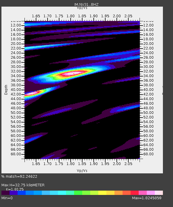
| Estimated Moho Depth: |
32.75 km |
| Estimated Crust Vp/Vs: |
1.81 |
| Assumed Crust Vp: |
6.279 km/s |
| Estimated Crust Vs: |
3.464 km/s |
| Estimated Crust Poisson's Ratio: |
0.28 |
|
| Radial Match: |
92.24622 % |
| Radial Bump: |
400 |
| Transverse Match: |
83.18722 % |
| Transverse Bump: |
400 |
| SOD ConfigId: |
26694651 |
| Insert Time: |
2022-03-02 07:28:51.182 +0000 |
| GWidth: |
2.5 |
| Max Bumps: |
400 |
| Tol: |
0.001 |
|

Signal To Noise
| Channel | StoN | STA | LTA |
| IM:NV31: :BHZ:20220216T07:18:30.149988Z | 4.6703053 | 6.3353156E-7 | 1.35651E-7 |
| IM:NV31: :BHN:20220216T07:18:30.149988Z | 1.1039687 | 2.6224404E-7 | 2.3754663E-7 |
| IM:NV31: :BHE:20220216T07:18:30.149988Z | 2.2054963 | 4.13832E-7 | 1.8763669E-7 |
| Arrivals |
| Ps | 4.6 SECOND |
| PpPs | 14 SECOND |
| PsPs/PpSs | 18 SECOND |


