You are here: Home > Network List > US - United States National Seismic Network Stations List
> Station DGMT Dagmar, Montana, USA > Earthquake Result Viewer
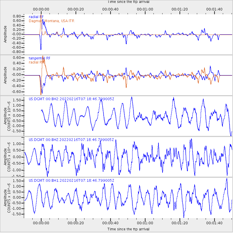
DGMT Dagmar, Montana, USA - Earthquake Result Viewer
*The percent match for this event was below the threshold and hence no stack was calculated.
| Earthquake location: |
Guatemala |
| Earthquake latitude/longitude: |
14.2/-91.3 |
| Earthquake time(UTC): |
2022/02/16 (047) 07:12:25 GMT |
| Earthquake Depth: |
84 km |
| Earthquake Magnitude: |
6.2 mww |
| Earthquake Catalog/Contributor: |
NEIC PDE/us |
|
| Network: |
US United States National Seismic Network |
| Station: |
DGMT Dagmar, Montana, USA |
| Lat/Lon: |
48.47 N/104.20 W |
| Elevation: |
0.0 m |
|
| Distance: |
35.8 deg |
| Az: |
345.29 deg |
| Baz: |
158.28 deg |
| Ray Param: |
$rayparam |
*The percent match for this event was below the threshold and hence was not used in the summary stack. |
|
| Radial Match: |
72.60682 % |
| Radial Bump: |
326 |
| Transverse Match: |
69.28211 % |
| Transverse Bump: |
290 |
| SOD ConfigId: |
26694651 |
| Insert Time: |
2022-03-02 07:34:47.196 +0000 |
| GWidth: |
2.5 |
| Max Bumps: |
400 |
| Tol: |
0.001 |
|
Signal To Noise
| Channel | StoN | STA | LTA |
| US:DGMT:00:BHZ:20220216T07:18:46.799005Z | 2.1387582 | 8.0339186E-7 | 3.7563476E-7 |
| US:DGMT:00:BH1:20220216T07:18:46.799005Z | 1.1530154 | 6.0387794E-7 | 5.2373804E-7 |
| US:DGMT:00:BH2:20220216T07:18:46.799005Z | 1.5238193 | 9.766472E-7 | 6.4092063E-7 |
| Arrivals |
| Ps | |
| PpPs | |
| PsPs/PpSs | |


