You are here: Home > Network List > UU - University of Utah Regional Network Stations List
> Station FOR7 FORGE > Earthquake Result Viewer
FOR7 FORGE - Earthquake Result Viewer
| Earthquake location: |
Guatemala |
| Earthquake latitude/longitude: |
14.2/-91.3 |
| Earthquake time(UTC): |
2022/02/16 (047) 07:12:25 GMT |
| Earthquake Depth: |
84 km |
| Earthquake Magnitude: |
6.2 mww |
| Earthquake Catalog/Contributor: |
NEIC PDE/us |
|
| Network: |
UU University of Utah Regional Network |
| Station: |
FOR7 FORGE |
| Lat/Lon: |
38.42 N/112.85 W |
| Elevation: |
1964 m |
|
| Distance: |
30.8 deg |
| Az: |
325.646 deg |
| Baz: |
135.833 deg |
| Ray Param: |
0.07914376 |
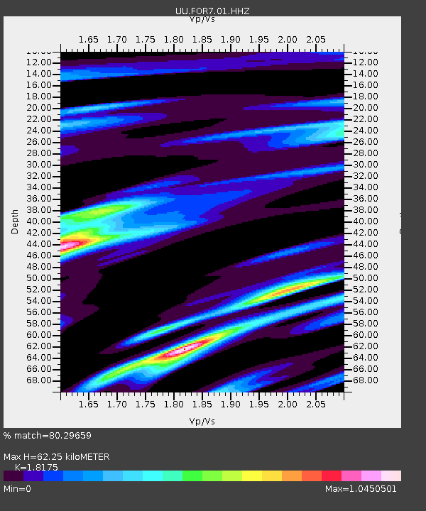
| Estimated Moho Depth: |
62.25 km |
| Estimated Crust Vp/Vs: |
1.82 |
| Assumed Crust Vp: |
6.276 km/s |
| Estimated Crust Vs: |
3.453 km/s |
| Estimated Crust Poisson's Ratio: |
0.28 |
|
| Radial Match: |
80.29659 % |
| Radial Bump: |
380 |
| Transverse Match: |
56.536877 % |
| Transverse Bump: |
400 |
| SOD ConfigId: |
26694651 |
| Insert Time: |
2022-03-02 07:35:25.835 +0000 |
| GWidth: |
2.5 |
| Max Bumps: |
400 |
| Tol: |
0.001 |
|

Signal To Noise
| Channel | StoN | STA | LTA |
| UU:FOR7:01:HHZ:20220216T07:18:03.064996Z | 2.4085498 | 3.2092672E-7 | 1.3324478E-7 |
| UU:FOR7:01:HHN:20220216T07:18:03.064996Z | 1.0220149 | 1.7833399E-7 | 1.7449256E-7 |
| UU:FOR7:01:HHE:20220216T07:18:03.064996Z | 1.0360516 | 2.0742716E-7 | 2.002093E-7 |
| Arrivals |
| Ps | 8.7 SECOND |
| PpPs | 26 SECOND |
| PsPs/PpSs | 35 SECOND |


