You are here: Home > Network List > UW - Pacific Northwest Regional Seismic Network Stations List
> Station HOPR Tall Timber Retreat WA > Earthquake Result Viewer
HOPR Tall Timber Retreat WA - Earthquake Result Viewer
| Earthquake location: |
Guatemala |
| Earthquake latitude/longitude: |
14.2/-91.3 |
| Earthquake time(UTC): |
2022/02/16 (047) 07:12:25 GMT |
| Earthquake Depth: |
84 km |
| Earthquake Magnitude: |
6.2 mww |
| Earthquake Catalog/Contributor: |
NEIC PDE/us |
|
| Network: |
UW Pacific Northwest Regional Seismic Network |
| Station: |
HOPR Tall Timber Retreat WA |
| Lat/Lon: |
47.92 N/120.89 W |
| Elevation: |
597 m |
|
| Distance: |
41.6 deg |
| Az: |
329.992 deg |
| Baz: |
133.85 deg |
| Ray Param: |
0.07339167 |
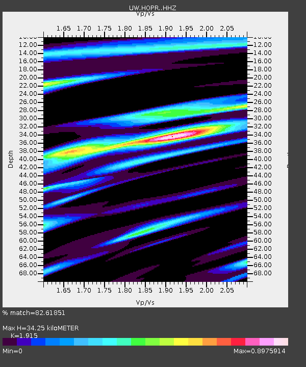
| Estimated Moho Depth: |
34.25 km |
| Estimated Crust Vp/Vs: |
1.91 |
| Assumed Crust Vp: |
6.597 km/s |
| Estimated Crust Vs: |
3.445 km/s |
| Estimated Crust Poisson's Ratio: |
0.31 |
|
| Radial Match: |
82.61851 % |
| Radial Bump: |
400 |
| Transverse Match: |
73.629616 % |
| Transverse Bump: |
400 |
| SOD ConfigId: |
26694651 |
| Insert Time: |
2022-03-02 07:36:08.111 +0000 |
| GWidth: |
2.5 |
| Max Bumps: |
400 |
| Tol: |
0.001 |
|

Signal To Noise
| Channel | StoN | STA | LTA |
| UW:HOPR: :HHZ:20220216T07:19:35.350Z | 4.2990212 | 9.1596826E-7 | 2.1306437E-7 |
| UW:HOPR: :HHN:20220216T07:19:35.350Z | 2.757942 | 5.6081535E-7 | 2.0334559E-7 |
| UW:HOPR: :HHE:20220216T07:19:35.350Z | 3.1292684 | 6.3663816E-7 | 2.0344632E-7 |
| Arrivals |
| Ps | 5.1 SECOND |
| PpPs | 14 SECOND |
| PsPs/PpSs | 19 SECOND |


