You are here: Home > Network List > US - United States National Seismic Network Stations List
> Station WUAZ Wupatki, Arizona, USA > Earthquake Result Viewer
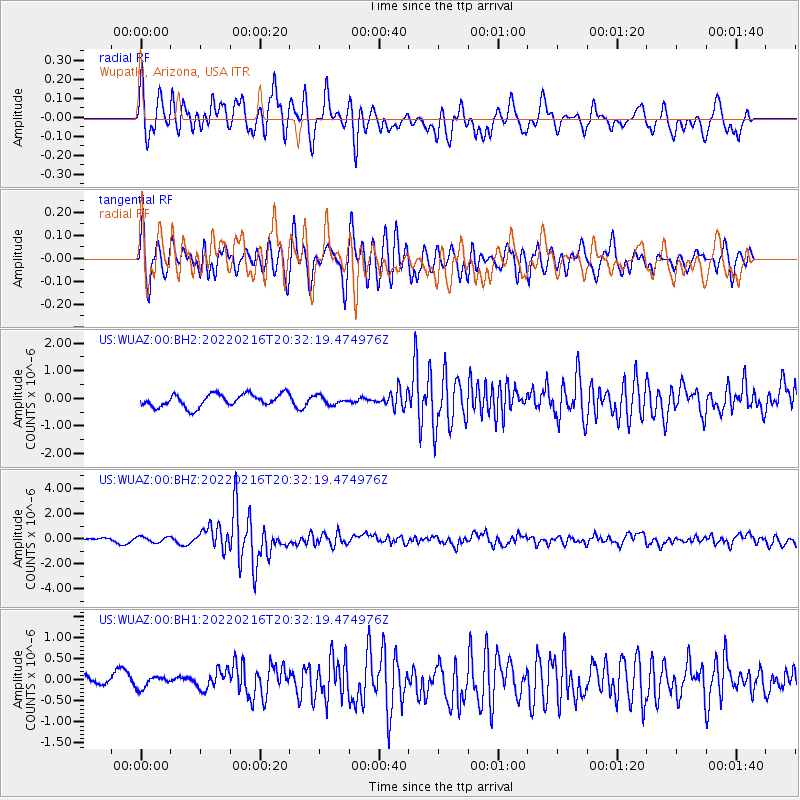
WUAZ Wupatki, Arizona, USA - Earthquake Result Viewer
*The percent match for this event was below the threshold and hence no stack was calculated.
| Earthquake location: |
South Of Fiji Islands |
| Earthquake latitude/longitude: |
-23.8/-179.7 |
| Earthquake time(UTC): |
2022/02/16 (047) 20:21:03 GMT |
| Earthquake Depth: |
568 km |
| Earthquake Magnitude: |
6.6 Mi |
| Earthquake Catalog/Contributor: |
NEIC PDE/at |
|
| Network: |
US United States National Seismic Network |
| Station: |
WUAZ Wupatki, Arizona, USA |
| Lat/Lon: |
35.52 N/111.37 W |
| Elevation: |
1592 m |
|
| Distance: |
87.5 deg |
| Az: |
49.362 deg |
| Baz: |
238.432 deg |
| Ray Param: |
$rayparam |
*The percent match for this event was below the threshold and hence was not used in the summary stack. |
|
| Radial Match: |
70.69855 % |
| Radial Bump: |
400 |
| Transverse Match: |
76.38552 % |
| Transverse Bump: |
400 |
| SOD ConfigId: |
26694651 |
| Insert Time: |
2022-03-02 20:35:40.409 +0000 |
| GWidth: |
2.5 |
| Max Bumps: |
400 |
| Tol: |
0.001 |
|
Signal To Noise
| Channel | StoN | STA | LTA |
| US:WUAZ:00:BHZ:20220216T20:32:19.474976Z | 1.3617454 | 2.2043287E-7 | 1.6187525E-7 |
| US:WUAZ:00:BH1:20220216T20:32:19.474976Z | 0.6768688 | 1.5566648E-7 | 2.299803E-7 |
| US:WUAZ:00:BH2:20220216T20:32:19.474976Z | 0.63815534 | 1.4671326E-7 | 2.2990211E-7 |
| Arrivals |
| Ps | |
| PpPs | |
| PsPs/PpSs | |


