You are here: Home > Network List > XE05 - Sierra Nevada EarthScope Project- EarthScope Flex Array Stations List
> Station SNP73 SNP73 > Earthquake Result Viewer
SNP73 SNP73 - Earthquake Result Viewer
| Earthquake location: |
Northern Peru |
| Earthquake latitude/longitude: |
-5.7/-76.4 |
| Earthquake time(UTC): |
2005/09/26 (269) 01:55:37 GMT |
| Earthquake Depth: |
115 km |
| Earthquake Magnitude: |
6.7 MB, 7.5 MW, 7.5 MW |
| Earthquake Catalog/Contributor: |
WHDF/NEIC |
|
| Network: |
XE Sierra Nevada EarthScope Project- EarthScope Flex Array |
| Station: |
SNP73 SNP73 |
| Lat/Lon: |
37.82 N/120.11 W |
| Elevation: |
982 m |
|
| Distance: |
59.4 deg |
| Az: |
320.504 deg |
| Baz: |
126.939 deg |
| Ray Param: |
0.061896905 |
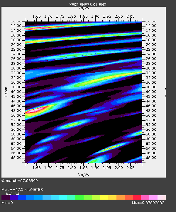
| Estimated Moho Depth: |
47.5 km |
| Estimated Crust Vp/Vs: |
1.64 |
| Assumed Crust Vp: |
6.391 km/s |
| Estimated Crust Vs: |
3.897 km/s |
| Estimated Crust Poisson's Ratio: |
0.20 |
|
| Radial Match: |
97.95909 % |
| Radial Bump: |
379 |
| Transverse Match: |
87.94837 % |
| Transverse Bump: |
400 |
| SOD ConfigId: |
268666 |
| Insert Time: |
2010-03-09 16:53:04.615 +0000 |
| GWidth: |
2.5 |
| Max Bumps: |
400 |
| Tol: |
0.001 |
|

Signal To Noise
| Channel | StoN | STA | LTA |
| XE:SNP73:01:BHZ:20050926T02:04:57.115007Z | 53.533325 | 1.5182143E-5 | 2.8360174E-7 |
| XE:SNP73:01:BHN:20050926T02:04:57.115007Z | 36.40761 | 4.8649067E-6 | 1.3362335E-7 |
| XE:SNP73:01:BHE:20050926T02:04:57.115007Z | 34.778316 | 5.8464416E-6 | 1.6810594E-7 |
| Arrivals |
| Ps | 5.0 SECOND |
| PpPs | 19 SECOND |
| PsPs/PpSs | 24 SECOND |


