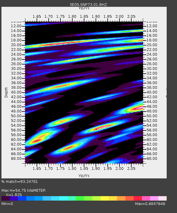
SNP73 SNP73 - Earthquake Result Viewer

Earthquake location: Near East Coast Of Honshu, Japan
Earthquake latitude/longitude: 36.4/140.8
Earthquake time(UTC): 2005/10/19 (292) 11:44:42 GMT
Earthquake Depth: 32 km
Earthquake Magnitude: 6.2 MB, 6.5 MS, 6.4 MW, 6.3 MW
Earthquake Catalog/Contributor: WHDF/NEIC
Network: XE Sierra Nevada EarthScope Project- EarthScope Flex Array
Station: SNP73 SNP73
Lat/Lon: 37.82 N/120.11 W
Elevation: 982 m
Distance: 74.9 deg
Az: 54.093 deg
Baz: 304.396 deg
Ray Param: 0.051972196
Estimated Moho Depth: 54.75 km
Estimated Crust Vp/Vs: 1.92
Assumed Crust Vp: 6.391 km/s
Estimated Crust Vs: 3.32 km/s
Estimated Crust Poisson's Ratio: 0.32
Radial Match: 93.24781 %
Radial Bump: 400
Transverse Match: 72.303955 %
Transverse Bump: 400
SOD ConfigId: 268666
Insert Time: 2010-03-09 16:53:10.489 +0000
GWidth: 2.5
Max Bumps: 400
Tol: 0.001

Signal To Noise

ChannelStoNSTALTA
XE:SNP73:01:BHZ:20051019T11:55:49.440024Z1.95178084.609547E-72.3617135E-7
XE:SNP73:01:BHN:20051019T11:55:49.440024Z1.94089511.8880522E-79.727739E-8
XE:SNP73:01:BHE:20051019T11:55:49.440024Z1.95556272.619745E-71.3396374E-7
Arrivals
Ps8.2 SECOND
PpPs24 SECOND
PsPs/PpSs32 SECOND