You are here: Home > Network List > TX - Texas Seismological Network Stations List
> Station RTBA Rita Blanca > Earthquake Result Viewer
RTBA Rita Blanca - Earthquake Result Viewer
| Earthquake location: |
Alaska Peninsula |
| Earthquake latitude/longitude: |
55.4/-158.0 |
| Earthquake time(UTC): |
2022/02/20 (051) 11:47:10 GMT |
| Earthquake Depth: |
20 km |
| Earthquake Magnitude: |
5.5 ml |
| Earthquake Catalog/Contributor: |
NEIC PDE/ak |
|
| Network: |
TX Texas Seismological Network |
| Station: |
RTBA Rita Blanca |
| Lat/Lon: |
36.44 N/102.74 W |
| Elevation: |
1284 m |
|
| Distance: |
41.6 deg |
| Az: |
93.491 deg |
| Baz: |
315.12 deg |
| Ray Param: |
0.07366661 |
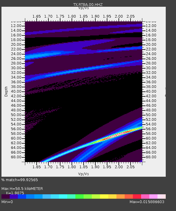
| Estimated Moho Depth: |
58.5 km |
| Estimated Crust Vp/Vs: |
1.99 |
| Assumed Crust Vp: |
6.306 km/s |
| Estimated Crust Vs: |
3.173 km/s |
| Estimated Crust Poisson's Ratio: |
0.33 |
|
| Radial Match: |
99.92565 % |
| Radial Bump: |
11 |
| Transverse Match: |
96.69713 % |
| Transverse Bump: |
232 |
| SOD ConfigId: |
26694651 |
| Insert Time: |
2022-03-06 12:04:07.671 +0000 |
| GWidth: |
2.5 |
| Max Bumps: |
400 |
| Tol: |
0.001 |
|

Signal To Noise
| Channel | StoN | STA | LTA |
| TX:RTBA:00:HHZ:20220220T11:54:25.765008Z | 0.19502395 | 7.1590436E-9 | 3.6708535E-8 |
| TX:RTBA:00:HH1:20220220T11:54:25.765008Z | 0.19584483 | 3.464133E-9 | 1.7688151E-8 |
| TX:RTBA:00:HH2:20220220T11:54:25.765008Z | 0.20028414 | 3.7657935E-9 | 1.8802254E-8 |
| Arrivals |
| Ps | 9.7 SECOND |
| PpPs | 26 SECOND |
| PsPs/PpSs | 36 SECOND |


