You are here: Home > Network List > US - United States National Seismic Network Stations List
> Station MIAR Mount Ida, Arkansas, USA > Earthquake Result Viewer
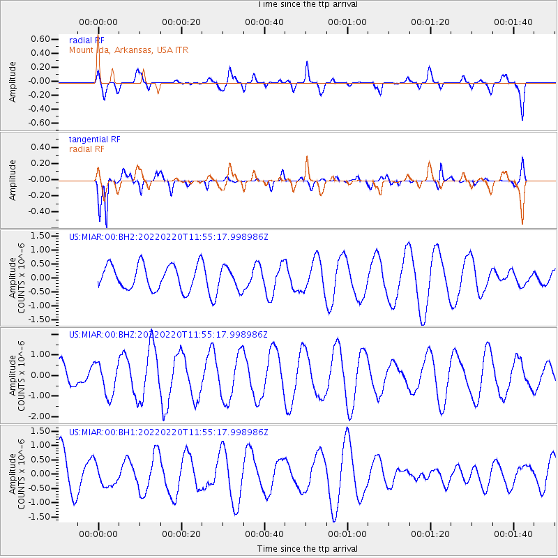
MIAR Mount Ida, Arkansas, USA - Earthquake Result Viewer
*The percent match for this event was below the threshold and hence no stack was calculated.
| Earthquake location: |
Alaska Peninsula |
| Earthquake latitude/longitude: |
55.4/-158.0 |
| Earthquake time(UTC): |
2022/02/20 (051) 11:47:10 GMT |
| Earthquake Depth: |
20 km |
| Earthquake Magnitude: |
5.5 ml |
| Earthquake Catalog/Contributor: |
NEIC PDE/ak |
|
| Network: |
US United States National Seismic Network |
| Station: |
MIAR Mount Ida, Arkansas, USA |
| Lat/Lon: |
34.55 N/93.58 W |
| Elevation: |
207 m |
|
| Distance: |
48.2 deg |
| Az: |
87.771 deg |
| Baz: |
316.362 deg |
| Ray Param: |
$rayparam |
*The percent match for this event was below the threshold and hence was not used in the summary stack. |
|
| Radial Match: |
70.09013 % |
| Radial Bump: |
374 |
| Transverse Match: |
76.39166 % |
| Transverse Bump: |
344 |
| SOD ConfigId: |
26694651 |
| Insert Time: |
2022-03-06 12:04:36.836 +0000 |
| GWidth: |
2.5 |
| Max Bumps: |
400 |
| Tol: |
0.001 |
|
Signal To Noise
| Channel | StoN | STA | LTA |
| US:MIAR:00:BHZ:20220220T11:55:17.998986Z | 1.8893654 | 7.9097737E-7 | 4.186471E-7 |
| US:MIAR:00:BH1:20220220T11:55:17.998986Z | 0.48788434 | 3.5648767E-7 | 7.306807E-7 |
| US:MIAR:00:BH2:20220220T11:55:17.998986Z | 0.87530726 | 3.8064445E-7 | 4.3486955E-7 |
| Arrivals |
| Ps | |
| PpPs | |
| PsPs/PpSs | |


