You are here: Home > Network List > AU - Australian Seismological Centre Stations List
> Station MUN Mundaring, Western Australia > Earthquake Result Viewer
MUN Mundaring, Western Australia - Earthquake Result Viewer
| Earthquake location: |
Balleny Islands Region |
| Earthquake latitude/longitude: |
-69.8/165.4 |
| Earthquake time(UTC): |
2022/02/21 (052) 23:24:13 GMT |
| Earthquake Depth: |
10 km |
| Earthquake Magnitude: |
6.6 mww |
| Earthquake Catalog/Contributor: |
NEIC PDE/us |
|
| Network: |
AU Australian Seismological Centre |
| Station: |
MUN Mundaring, Western Australia |
| Lat/Lon: |
31.98 S/116.21 E |
| Elevation: |
253 m |
|
| Distance: |
46.6 deg |
| Az: |
297.665 deg |
| Baz: |
158.745 deg |
| Ray Param: |
0.07055849 |
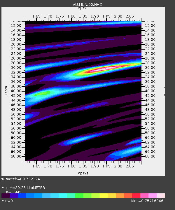
| Estimated Moho Depth: |
30.25 km |
| Estimated Crust Vp/Vs: |
1.95 |
| Assumed Crust Vp: |
6.419 km/s |
| Estimated Crust Vs: |
3.3 km/s |
| Estimated Crust Poisson's Ratio: |
0.32 |
|
| Radial Match: |
89.732124 % |
| Radial Bump: |
211 |
| Transverse Match: |
76.21383 % |
| Transverse Bump: |
400 |
| SOD ConfigId: |
26694651 |
| Insert Time: |
2022-03-07 23:26:40.263 +0000 |
| GWidth: |
2.5 |
| Max Bumps: |
400 |
| Tol: |
0.001 |
|

Signal To Noise
| Channel | StoN | STA | LTA |
| AU:MUN:00:HHZ:20220221T23:32:10.200Z | 10.621649 | 1.831398E-6 | 1.7242125E-7 |
| AU:MUN:00:HHN:20220221T23:32:10.200Z | 7.3534307 | 1.0933236E-6 | 1.486821E-7 |
| AU:MUN:00:HHE:20220221T23:32:10.200Z | 3.3027248 | 4.7629592E-7 | 1.4421302E-7 |
| Arrivals |
| Ps | 4.7 SECOND |
| PpPs | 13 SECOND |
| PsPs/PpSs | 18 SECOND |


